

CENTRE– The National Weather Service in Birmingham has issued a Flood Watch for Cherokee, Etowah, and Blount counties.
The watch begins Thursday morning and continues through Saturday morning. It includes Centre, Gadsden, Oneonta, and surrounding communities.
Excessive Rainfall Could Cause Flooding
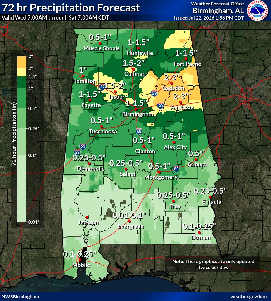
Forecasters say excessive rainfall could lead to flooding during the watch period. However, a flood watch means flooding remains possible, not certain.
Heavy rain and runoff could raise water levels along rivers, creeks, and streams. In addition, water may collect quickly in low-lying areas and other flood-prone locations.
Residents should continue monitoring weather updates because the National Weather Service may issue flood warnings if conditions worsen. Those living near waterways or in flood-prone areas should prepare to act if water begins rising.
Prepare Before Flooding Develops
The National Weather Service recommends creating a family communication plan and identifying a safe meeting place. Families should also know the quickest route to higher ground.
In addition, residents should prepare an emergency kit with enough food, water, and medicine for at least three days. The kit should include flashlights, batteries, a first-aid kit, blankets, and a battery-powered radio.
Residents should charge cellphones and other essential electronics before the heaviest rain arrives. They should also prepare supplies for children, older family members, and pets.
Those who live in flood-prone areas should secure outdoor items and protect their property when it remains safe to do so. More preparation information is available through the National Weather Service flood safety guide.
Never Enter Floodwater
<iframe width=”560″ height=”315″ src=”https://www.youtube.com/embed/eI6mIlHKrVY?si=U8J8EEDfQkpeaO8l” title=”YouTube video player” frameborder=”0″ allow=”accelerometer; autoplay; clipboard-write; encrypted-media; gyroscope; picture-in-picture; web-share” referrerpolicy=”strict-origin-when-cross-origin” allowfullscreen></iframe>
The National Weather Service urges drivers to avoid flooded roads and never travel around a barricade. Water may cover damaged pavement, electrical wires, sharp objects, or other hidden dangers.
Only six inches of moving water can knock a person off their feet. Meanwhile, 12 inches can float a car or small sport utility vehicle. About 18 inches can carry away larger vehicles.
Drivers who encounter water covering a roadway should turn around and find another route. The National Weather Service emphasizes the safety message, “Turn Around, Don’t Drown.”
Anyone in a flood-prone location should move to higher ground if water begins rising. Residents should also follow evacuation instructions immediately and avoid walking through floodwater.
Additional information about staying safe during flooding is available from the National Weather Service.


You must be logged in to post a comment.