
Waves of showers and storms will occur through midday Monday, including a risk for severe storms and flooding. As of the 3 pm hour, we continue to assess the most likely evolution of storms and placement of unstable air. A Severe Thunderstorm Watch and/or Tornado Watch could become necessary for part of central Alabama over the coming hours. We are also closely watching areas just south of the current Flood Watch as training showers and storms could end up more prominent than earlier indicated and, if so, may require an expansion of the Flood Watch to those locations.
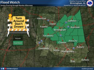
Changes from previous forecast: Flood Watch issued for part of central Alabama.
Highlights: Severe Round One:
Where: Nearly all of central Alabama
When: Through 6 am Monday
Threats: Tornadoes, damaging winds up to 60 mph, and quarter-size hail
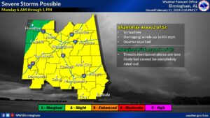
Severe Round Two:
Where: Nearly all of central Alabama
When: Monday 6 am to 1 pm
Threats: Tornadoes, damaging winds up to 60 mph, and quarter-size hail
Flooding:
Where: Areas covered by the Flood Watch could see instances of notable flooding
When: Sunday evening through Monday afternoon
Threats: Flooding of creeks, streams, urban, and low-lying/poor-drainage areas
STAY TUNED TO WEIS RADIO FOR UPDATES, 100.5 FM, 990 AM, ONLINE AT WEISRADIO.COM, AND ON THE WEIS RADIO APP.


You must be logged in to post a comment.