
Flood Watch
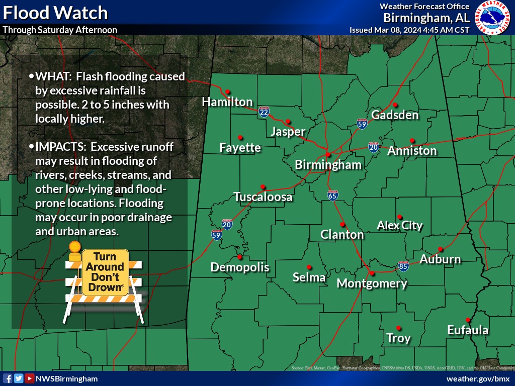
Flood Watch
National Weather Service Birmingham AL
442 AM CST Fri Mar 8 2024

.Heavy rainfall that may lead to flash flooding is expected to
arrive as late this morning and may persist through early Saturday
afternoon. Rainfall amounts of 2 to 5 inches with locally higher
amounts are likely. Heavy rainfall that occurs is expected to
rapidly run off due to fairly wet soil conditions currently in place
across central Alabama. Flash flooding will be possible as a result,
along with rises on small streams and drainage basins.

ALZ011>015-017>050-082100-
/O.CON.KBMX.FA.A.0003.240308T1800Z-240309T2100Z/
/00000.0.ER.000000T0000Z.000000T0000Z.000000T0000Z.OO/
Marion-Lamar-Fayette-Winston-Walker-Blount-Etowah-Calhoun-
Cherokee-Cleburne-Pickens-Tuscaloosa-Jefferson-Shelby-St. Clair-
Talladega-Clay-Randolph-Sumter-Greene-Hale-Perry-Bibb-Chilton-
Coosa-Tallapoosa-Chambers-Marengo-Dallas-Autauga-Lowndes-Elmore-
Montgomery-Macon-Bullock-Lee-Russell-Pike-Barbour-
Including the cities of Hamilton, Pelham, Alexander City, Union
Springs, Demopolis, Sulligent, Wetumpka, Tuskegee, Selma, Jasper,
Moundville, Eutaw, Valley, Roanoke, Pell City, Sylacauga, Centre,
Gadsden, Linden, Lafayette, Vernon, Clanton, Prattville,
Montgomery, Auburn, Eufaula, Tallassee, Hayneville, Ashland,
Dadeville, Greensboro, Lanett, Hoover, Fort Deposit, Fayette,
Heflin, Oneonta, Anniston, Rockford, Moody, Double Springs,
Alabaster, Talladega, Birmingham, Phenix City, Opelika, Marion,
Tuscaloosa, Troy, Carrollton, Centreville, Livingston, and
Columbiana
442 AM CST Fri Mar 8 2024

...FLOOD WATCH REMAINS IN EFFECT FROM NOON CST TODAY THROUGH
SATURDAY AFTERNOON...

* WHAT...Flash flooding caused by excessive rainfall continues to be
  possible.

* WHERE...All of central Alabama, including the following counties,
  Autauga, Barbour, Bibb, Blount, Bullock, Calhoun, Chambers,
  Cherokee, Chilton, Clay, Cleburne, Coosa, Dallas, Elmore, Etowah,
  Fayette, Greene, Hale, Jefferson, Lamar, Lee, Lowndes, Macon,
  Marengo, Marion, Montgomery, Perry, Pickens, Pike, Randolph,
  Russell, Shelby, St. Clair, Sumter, Talladega, Tallapoosa,
  Tuscaloosa, Walker and Winston.

* WHEN...From noon CST today through Saturday afternoon.

* IMPACTS...Excessive runoff may result in flooding of rivers,
  creeks, streams, and other low-lying and flood-prone locations.
  Flooding may occur in poor drainage and urban areas.

* ADDITIONAL DETAILS...
  - http://www.weather.gov/safety/flood
Flood Watch
Flood Watch
National Weather Service Huntsville AL
643 AM CST Fri Mar 8 2024

ALZ008-010-016-082300-
/O.CON.KHUN.FA.A.0002.240308T1800Z-240309T1800Z/
/00000.0.ER.000000T0000Z.000000T0000Z.000000T0000Z.OO/
Marshall-DeKalb-Cullman-
Including the cities of Arab, Albertville, Cullman, Fort Payne,
Guntersville, Boaz, and Rainsville
643 AM CST Fri Mar 8 2024

...FLOOD WATCH REMAINS IN EFFECT FROM NOON CST TODAY THROUGH
SATURDAY MORNING...

* WHAT...Flash flooding caused by excessive rainfall continues to be
  possible.

* WHERE...Portions of north central and northeast Alabama, including
  the following counties, in north central Alabama, Cullman. In
  northeast Alabama, DeKalb and Marshall.

* WHEN...From noon CST today through Saturday morning.

* IMPACTS...Excessive runoff may result in flooding of rivers,
  creeks, streams, and other low-lying and flood-prone locations.
  Flooding may occur in poor drainage and urban areas.

* ADDITIONAL DETAILS...
  - Forecast rainfall amounts between 1.5-2 inches, with locally
    higher amounts possible, are anticipated across Cullman,
    Marshall, and DeKalb counties through Saturday afternoon.
  - http://www.weather.gov/safety/flood

PRECAUTIONARY/PREPAREDNESS ACTIONS...

You should monitor later forecasts and be prepared to take action
should Flash Flood Warnings be issued.
Flood Watch
Flood Watch
National Weather Service Peachtree City GA
248 AM EST Fri Mar 8 2024

GAZ001>009-011>016-019>025-027-030>039-041>062-066>076-078>084-
089>095-102-082015-
/O.CON.KFFC.FA.A.0004.240309T0000Z-240310T0600Z/
/00000.0.ER.000000T0000Z.000000T0000Z.000000T0000Z.OO/
Dade-Walker-Catoosa-Whitfield-Murray-Fannin-Gilmer-Union-Towns-
Chattooga-Gordon-Pickens-Dawson-Lumpkin-White-Floyd-Bartow-
Cherokee-Forsyth-Hall-Banks-Jackson-Madison-Polk-Paulding-Cobb-
North Fulton-Gwinnett-Barrow-Clarke-Oconee-Oglethorpe-Wilkes-
Haralson-Carroll-Douglas-South Fulton-DeKalb-Rockdale-Walton-
Newton-Morgan-Greene-Taliaferro-Heard-Coweta-Fayette-Clayton-
Spalding-Henry-Butts-Jasper-Putnam-Hancock-Warren-Troup-
Meriwether-Pike-Upson-Lamar-Monroe-Jones-Baldwin-Washington-
Glascock-Jefferson-Harris-Talbot-Taylor-Crawford-Bibb-Twiggs-
Wilkinson-Muscogee-Chattahoochee-Marion-Schley-Macon-Peach-
Houston-Stewart-
Including the cities of , Riverdale, Eatonton, Rome, Franklin,
Newnan, Jasper, East Point, Gainesville, Blairsville, Thomaston,
Douglasville, Winder, Dallas, Atlanta, Butler, Ellijay, Sparta,
West Point, Pine Mountain, Warrenton, Monticello, Fort Valley,
Chatsworth, Jackson, Cleveland, Decatur, Toomsboro, Montezuma,
Athens, Hiawassee, Columbus, Commerce, Milledgeville,
Cartersville, Barnesville, Madison, Macon, Fort Moore, Gray,
Peachtree City, Conyers, Forsyth, Monroe, Trenton, Woodstock,
Dawsonville, Fort Oglethorpe, Comer, Ellaville, Calhoun,
Carrollton, Jeffersonville, LaFayette, Bremen, Stockbridge,
Watkinsville, Talbotton, Dalton, Crawford, Manchester, Roberts,
Cumming, Louisville, Warner Robins, Dahlonega, Sandersville,
Lumpkin, Greensboro, Washington, Crawfordville, GIbson, Marietta,
Lawrenceville, Zebulon, Summerville, Homer, Buena Vista, Griffin,
Cedartown, and Covington
248 AM EST Fri Mar 8 2024

...FLOOD WATCH REMAINS IN EFFECT FROM THIS EVENING THROUGH LATE
SATURDAY NIGHT...

* WHAT...Flash flooding caused by excessive rainfall continues to be
  possible.

* WHERE...Portions of central, east central, north central,
  northeast, northwest, and west central Georgia, including the
  following areas, in central Georgia, Baldwin, Bibb, Butts,
  Crawford, Houston, Jasper, Jones, Monroe, Peach, Putnam, Twiggs
  and Wilkinson. In east central Georgia, Glascock, Greene, Hancock,
  Jefferson, Taliaferro, Warren, Washington and Wilkes. In north
  central Georgia, Barrow, Cherokee, Clayton, Cobb, Dawson, DeKalb,
  Douglas, Fannin, Fayette, Forsyth, Gilmer, Gwinnett, Hall, Henry,
  Lumpkin, Morgan, Newton, North Fulton, Pickens, Rockdale, South
  Fulton, Union and Walton. In northeast Georgia, Banks, Clarke,
  Jackson, Madison, Oconee, Oglethorpe, Towns and White. In
  northwest Georgia, Bartow, Carroll, Catoosa, Chattooga, Dade,
  Floyd, Gordon, Haralson, Murray, Paulding, Polk, Walker and
  Whitfield. In west central Georgia, Chattahoochee, Coweta, Harris,
  Heard, Lamar, Macon, Marion, Meriwether, Muscogee, Pike, Schley,
  Spalding, Stewart, Talbot, Taylor, Troup and Upson.

* WHEN...From this evening through late Saturday night.

* IMPACTS...Excessive runoff may result in flooding of rivers,
  creeks, streams, and other low-lying and flood-prone locations.
  Area creeks and streams are running high and could flood with more
  heavy rain.

* ADDITIONAL DETAILS...
  - A storm system will produce moderate to heavy rainfall in the
    region between Friday night and Saturday night. Rainfall
    totals of 2 to 5 inches are expected, with locally higher
    amounts possible. This rainfall combined with saturated soil
    conditions will likely produce flooding.
  - http://www.weather.gov/safety/flood

PRECAUTIONARY/PREPAREDNESS ACTIONS...

You should monitor later forecasts and be prepared to take action
should Flash Flood Warnings be issued.


You must be logged in to post a comment.