

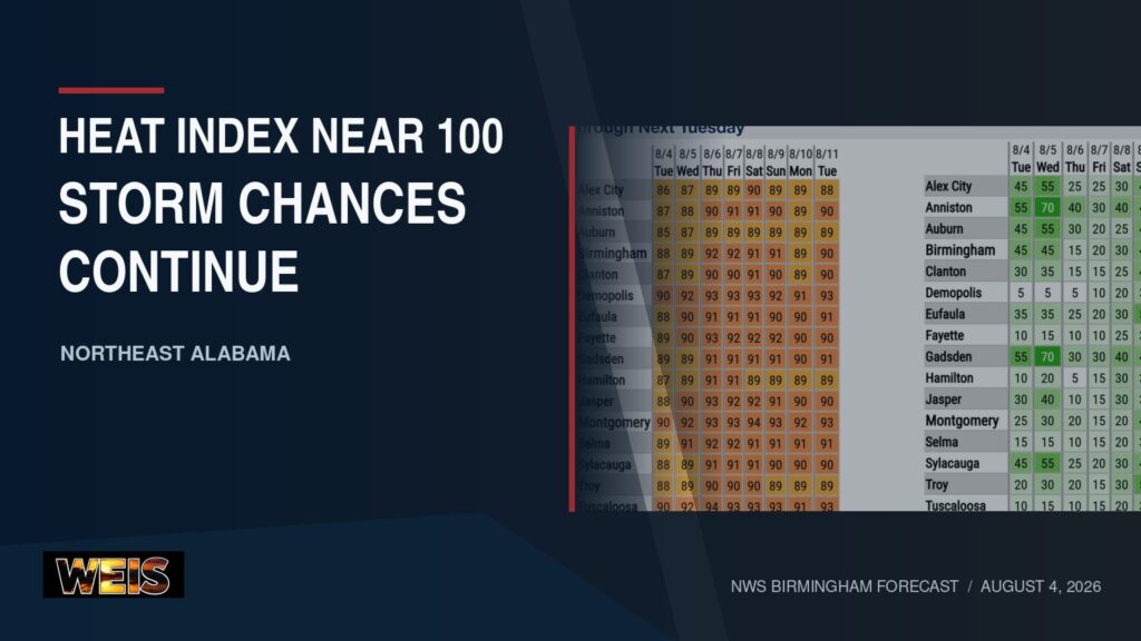
BIRMINGHAM– Increasing humidity will push afternoon heat-index values toward 100 degrees across Central and Northeast Alabama as daily shower and thunderstorm chances continue.
The National Weather Service in Birmingham said heat-index values should range from 95 to 100 degrees during the afternoon hours around midweek.
Isolated showers and a few thunderstorms will remain possible through Wednesday. More typical summertime storm activity should return later this week, with the best chances during the afternoon and early evening.
Rain Chances Highest Wednesday
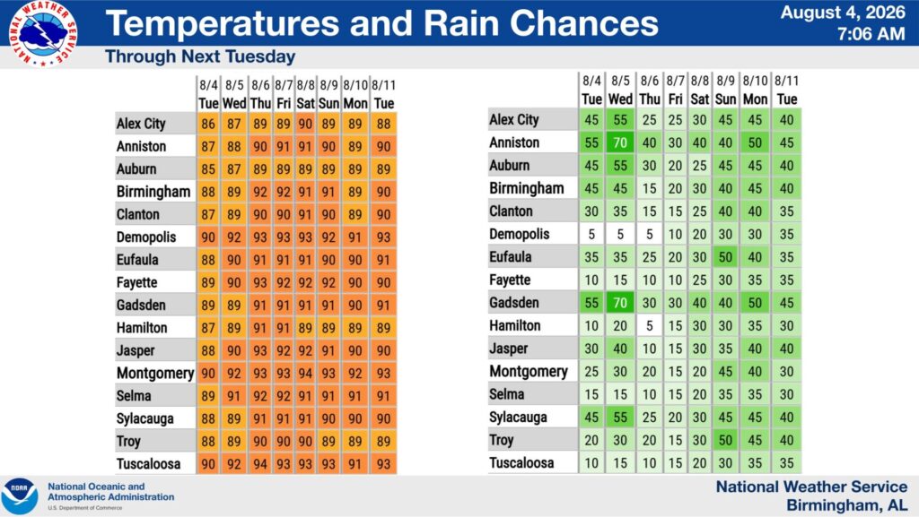
The National Weather Service projects a 55% rain chance Tuesday for both Gadsden and Anniston. Those probabilities increase to 70% Wednesday.
Rain chances then decrease but do not disappear.
Gadsden has a 30% chance Thursday and Friday. The probability increases to 40% Saturday and Sunday, 50% Monday and 45% next Tuesday.
Anniston has a 40% rain chance Thursday, followed by 30% Friday. Rain chances stand at 40% Saturday and Sunday, 50% Monday and 45% next Tuesday.
The forecast probabilities describe the chance of measurable rain at a given location. They do not mean rain will continue throughout the entire day.
Instead, storms should generally remain scattered. Some communities could receive rain while nearby locations remain dry.
Temperatures Climb Into the Lower 90s
The temperature outlook keeps daytime highs in the upper 80s and lower 90s across the region.
Gadsden should reach approximately 89 degrees Tuesday and Wednesday. Forecast highs rise to 91 Thursday through Sunday, followed by 90 Monday and 91 next Tuesday.
Anniston should reach 87 Tuesday and 88 Wednesday. Forecast highs climb to 90 Thursday and 91 Friday and Saturday.
Anniston’s projected high falls to 90 Sunday, 89 Monday and 90 next Tuesday.
Although those temperatures remain below the hottest readings of the summer, higher humidity will make conditions feel warmer. The resulting heat-index values could reach 95 to 100 degrees during the afternoon.
Above-Average Temperatures Favored Into Mid-August
Longer-range outlooks continue to favor above-average temperatures across Alabama.
The Climate Prediction Center’s six- to 10-day outlook covers Aug. 9 through Aug. 13. It places Alabama within a broad area where above-average temperatures are favored.
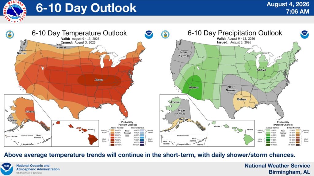
The accompanying rain outlook supports continued daily shower and thunderstorm opportunities. However, it does not indicate a prolonged period of widespread rain across Northeast Alabama.
The eight- to 14-day outlook covers Aug. 11 through Aug. 17. It continues to favor above-average temperatures across the Southeast.
Forecasters expressed high confidence in the warmer-than-average trend. Meanwhile, rainfall should remain near normal across the region during that period.
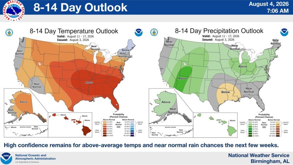
A longer-range outlook does not provide specific daily temperatures or storm timing. Instead, it compares the expected overall pattern with historical averages for the same time of year.
Part of Cherokee County Remains Abnormally Dry
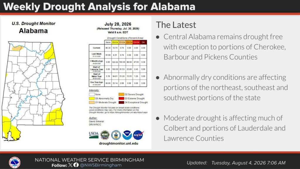
Most of Central Alabama remains free of drought conditions. However, the latest analysis shows abnormally dry conditions affecting part of Cherokee County.
Similar conditions appear across other portions of northeastern, southeastern and southwestern Alabama.
“Abnormally dry” is the lowest category on the U.S. Drought Monitor and is labeled D0. It identifies areas experiencing dryness that could precede drought or show lingering effects after drought.
D0 does not qualify as one of the monitor’s four drought categories.
The analysis shows moderate drought across much of Colbert County and portions of Lauderdale and Lawrence counties in northwestern Alabama. Moderate drought is classified as D1.
The drought map included in Tuesday’s briefing reflects conditions as of July 28 and was released July 30.
Atlantic Basin Remains Quiet

No tropical disturbances were present in the Atlantic basin when the Tuesday morning briefing was prepared.
The National Hurricane Center did not expect tropical cyclone development during the following seven days.
The outlook covers the Atlantic Ocean, Caribbean Sea and Gulf. Tropical conditions can change, especially during the active portion of hurricane season. Therefore, residents should continue monitoring later forecasts even when no immediate development is expected.
The National Weather Service said its next routine web briefing is planned for next Tuesday. Forecasters may issue an earlier briefing if weather conditions require one.
Because forecast information can change, residents should monitor updated information from the National Weather Service and local media.



You must be logged in to post a comment.