
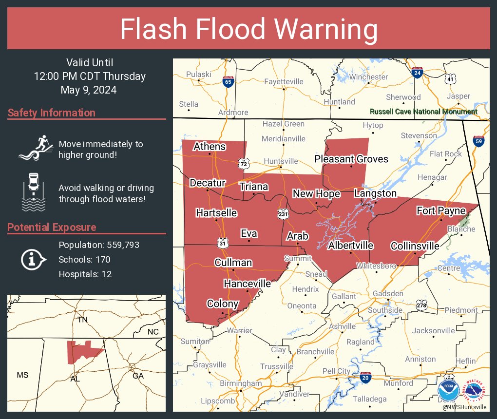
Flash Flood Warning
Flash Flood Warning
ALC043-049-071-083-089-095-103-091700-
/O.NEW.KHUN.FF.W.0007.240509T1353Z-240509T1700Z/
/00000.0.ER.000000T0000Z.000000T0000Z.000000T0000Z.OO/

BULLETIN - EAS ACTIVATION REQUESTED
Flash Flood Warning
National Weather Service Huntsville AL
853 AM CDT Thu May 9 2024

The National Weather Service in Huntsville has issued a

* Flash Flood Warning for...
  Cullman County in north central Alabama...
  Southeastern Limestone County in north central Alabama...
  Southern Madison County in north central Alabama...
  Morgan County in north central Alabama...
  DeKalb County in northeastern Alabama...
  Western Jackson County in northeastern Alabama...
  Marshall County in northeastern Alabama...

* Until noon CDT.

* At 853 AM CDT, Doppler radar indicated thunderstorms producing
  heavy rain across northern Alabama. Between 2 and 3 inches of rain
  have fallen. Additional rainfall amounts of 1 to 1.5 inches are
  possible in the warned area. Flash flooding is ongoing and
  mudslides are a threat near hilly terrain. There are numerous
  reports of water rushing over roadways and at least one mudslide
  in Marshall county on AL 227 mile marker 36 with one foot of mud
  on all but one lane.

  HAZARD...Flash flooding caused by thunderstorms.

  SOURCE...Radar and emergency manager reports.

  IMPACT...Flash flooding of small creeks and streams, urban
           areas, highways, streets and underpasses as well as
           other poor drainage and low-lying areas.

* Some locations that will experience flash flooding include...
  Southern Huntsville, Decatur, Madison, Athens, Albertville,
  Cullman, Scottsboro, Hartselle, Fort Payne, Boaz, Guntersville,
  Arab, Rainsville, Redstone Arsenal, Hanceville, Priceville, Good
  Hope, Trinity, Crossville and Sylvania.

PRECAUTIONARY/PREPAREDNESS ACTIONS...

Turn around, don`t drown when encountering flooded roads. Most flood
deaths occur in vehicles.

In hilly terrain there are hundreds of low water crossings which are
potentially dangerous in heavy rain. Do not attempt to cross flooded
roads. Find an alternate route. Mudslides are also a hazard.

Please report observed flooding to local emergency services or law
enforcement and request they pass this information to the National
Weather Service when you can do so safely.

&&

LAT...LON 3487 8677 3470 8679 3469 8637 3488 8634
      3489 8611 3459 8614 3453 8551 3424 8584
      3420 8584 3418 8619 3410 8630 3426 8644
      3425 8651 3412 8660 3409 8669 3397 8677
      3388 8692 3387 8692 3390 8710 3488 8712

FLASH FLOOD...RADAR INDICATED


You must be logged in to post a comment.