
A strong weather system is expected to move through the area late this evening through Tuesday morning. This system will bring the threat for severe weather, damaging winds outside thunderstorms, and heavy rainfall. Winds will gradually increase from now through the overnight hours. Winds may gust up to 40-50 mph, which may lead to downed trees and power outages.Rainfall amounts are forecasted to be 2-6″ with localized higher amounts, which may lead to flooding concerns in urban and/or poor drainage areas.
Severe Threat 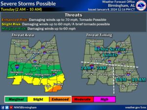
Where: Southern half of Central Alabama
When: Tuesday 2 AM to 10 AM
Threats: Damaging winds up to 60 mph
A brief tornado possible
Isolated flash flooding
Strong Winds: 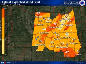
Where: All of Central Alabama
When: 3 PM today through 6 PM Tuesday
Threats: Sustained winds 20-30 mph with wind gusts 40-50 mph through Tuesday morning, decreasing in the afternoon.


You must be logged in to post a comment.