
 Severe Weather Statement
National Weather Service Birmingham AL
359 PM CDT Mon Jul 3 2023
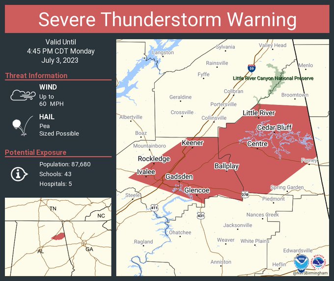
…A SEVERE THUNDERSTORM WARNING REMAINS IN EFFECT UNTIL 445 PM CDT FOR EASTERN ETOWAH AND CHEROKEE COUNTIES…
At 359 PM CDT, severe thunderstorms were located along a line extending from near Sand Rock to near Noccalula Falls, moving east at 25 mph.
HAZARD…60 mph wind gusts.
SOURCE…Radar indicated.
IMPACT…Expect damage to roofs, siding, and trees.
Locations impacted include…
Gadsden, Rainbow City, Attalla, Hokes Bluff, Centre, Cedar Bluff, Centre Municipal Airport, Glencoe, Leesburg, Reece City, Sand Rock, Gaylesville, Tennala, Tabor Road, Cherokee Rock Village, Cornwall Furnace Park, Eastern Weiss Lake, Ballplay, Slackland and Gadsden Mall.
PRECAUTIONARY/PREPAREDNESS ACTIONS…
For your protection move to an interior room on the lowest floor of a building.
HAIL THREAT…RADAR INDICATED
MAX HAIL SIZE…<.75 IN
WIND THREAT…RADAR INDICATED
MAX WIND GUST…60 MPH


You must be logged in to post a comment.