 Severe Weather Possible TODAY (Friday) across Alabama; Tornado Watch Issued
Severe weather will be possible across all of Alabama on Friday.
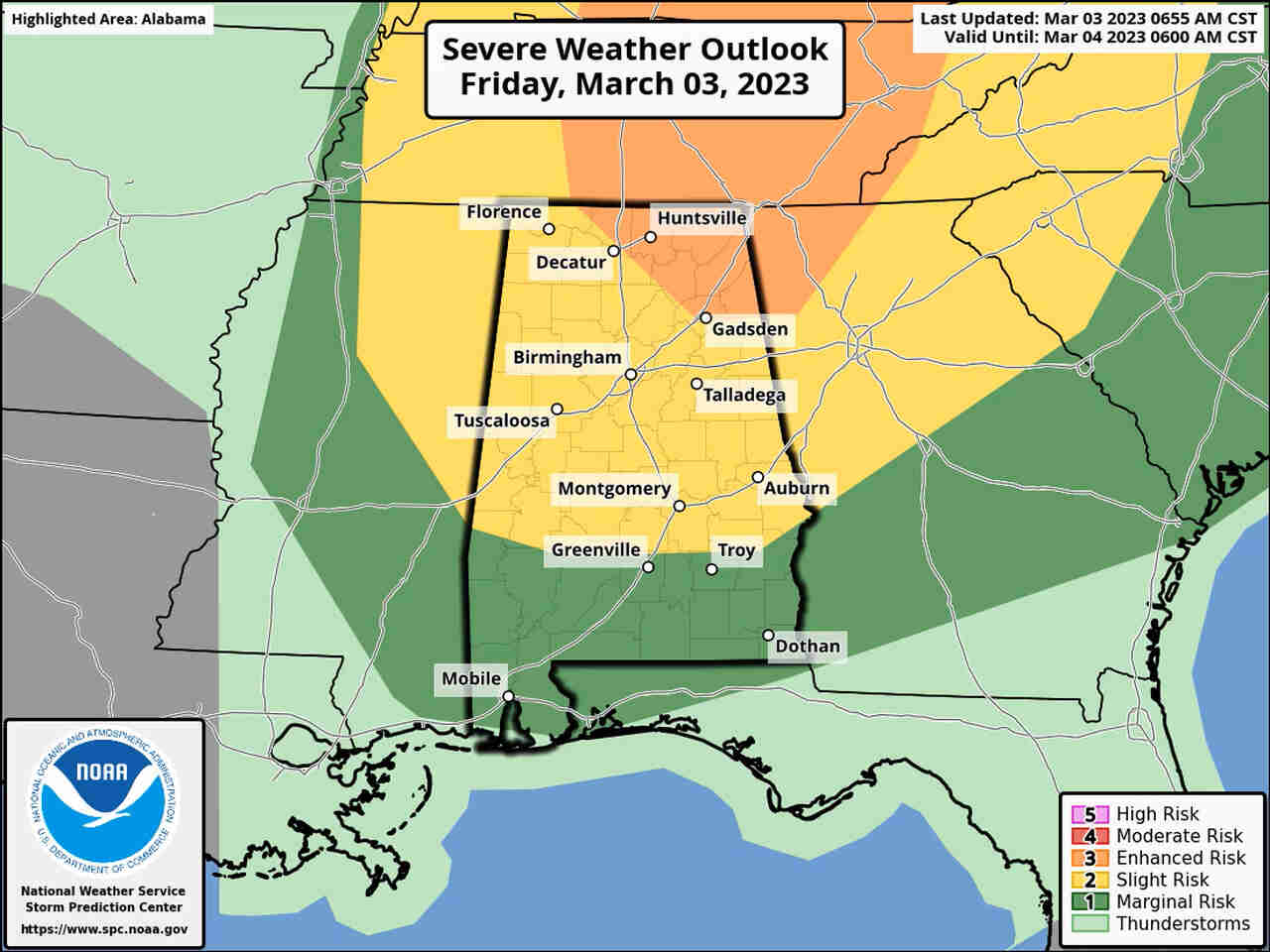
A Level 3 out of 5 risk has been added, and also expanded ,for north Alabama – where numerous severe storms will be possible.
Storms are expected to make it to west Alabama later this morning and quickly track eastward across the state, but they could arrive a bit later than originally forecast.
Strong to severe storms and high winds will be possible across Alabama on Friday, according to the National Weather Service.
Key points for today:
* A tornado watch has been issued for north and north-central Alabama and will be in effect until 1 p.m. Friday. The National Weather Service in Huntsville said another watch will be possible later today for areas to the east.
* The timing of the arrival of storms has been pushed back again, according to forecasters. Storms could reach Alabama’s western border anywhere from 7 a.m. onward on Friday morning, and the storms are expected to quickly track eastward across the state into the afternoon hours.
* NOAA’s Storm Prediction Center has added — and now expanded — a Level 3 out of 5 or enhanced risk for severe weather for north Alabama. The latest update now includes Huntsville in the Level 3 risk area. The thinking is that this area will have more time to heat up and become more favorable for strong storms this afternoon thanks to the slower storm arrival time. The northern two-thirds of the state remains in a Level 2 severe weather risk, and a Level 1 risk extends southward to the Gulf Coast.
* Tornadoes, damaging winds and hail will all be possible as storms move through Alabama today. Storms are expected to be moving quickly once they arrive.
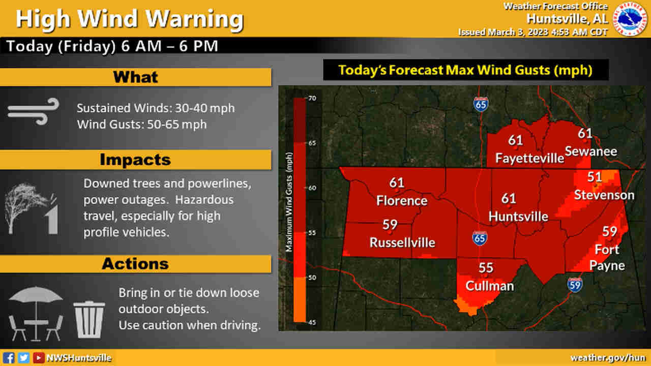
* High winds will be possible away from today’s storms. The entire state will be under wind advisories today, and a high wind warning is in effect for all of north Alabama until 6 p.m. Winds could gust up to 65 mph or higher in that region today, and downed trees and power lines will be possible.
More details:
Alabama remains poised to see another round of severe weather today, and the National Weather Service continued to watch storms developing to the west of the state.
Here’s a look at the situation early Friday morning:
The Storm Prediction Center has added a Level 3 out of 5 risk for severe weather for northeast Alabama. A Level 3, or enhanced, risk means that “numerous” severe storms will be possible.
The rest of north Alabama and central Alabama remain in a Level 2 risk, which means that scattered severe storms will be possible.
South Alabama has a Level 1 risk and could see isolated severe storms.
Tornadoes, damaging winds — some could gust to 80 mph — hail and heavy rain will be possible. Widespread flash flooding is not anticipated because the storms are expected to be moving fast today.
It could be very windy away from severe weather. All of north Alabama is under a rarely-used high wind warning, and the National Weather Service said winds could gust up to 65 mph. Winds that high combined with recent heavy rain in north Alabama could make it easier to bring down trees and knock out power.
All of north Alabama will be under a high wind warning until 6 p.m. Friday.
The rest of the state will be under wind advisories today, and winds could gust as high as 50 mph in other areas, also potentially downing power lines and trees.
The National Weather Service has pushed back the arrival time for storms, which could potentially increase the chances for severe weather. The slower arrival time means that Alabama has time to heat up and conditions could become more favorable for storms to intensify.
However, if clouds and spotty showers stay around then temperatures may not rise as much as they could, which could dampen the storm threat some.
The Storm Prediction Center has issued a tornado watch for north and north-central Alabama that will be in effect until 1 p.m.
The Alabama counties in the watch are Lauderdale, Colbert, Franklin, Lawrence, Limestone, Madison, Morgan, Marshall, Cullman, Fayette, Walker, Winston, Lamar and Marion.
The rest of Alabama could also see severe storms today. Storms will be possible through the afternoon hours.