
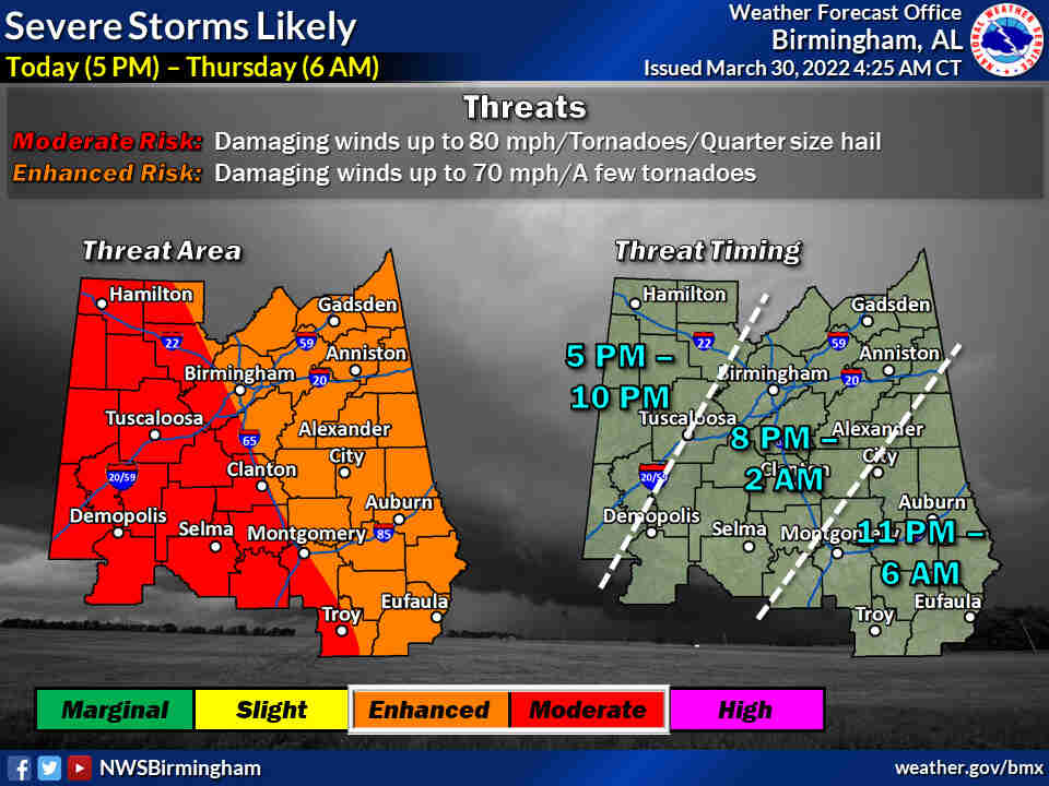
A line of strong storms is expected this evening into the early morning hours of Thursday.
There is the potential for widespread and damaging straight-line winds up to 80 miles per hour, tornadoes, and hail up to one inch in diameter.
Non-thunderstorm winds now to Thursday morning; sustained 15 to 25 mph with 45 to 55 mph gusts.
We encourage you to take ALL warnings seriously and have a place to shelter as the line of storms moves across the county. Remember, the smallest interior room on the lowest floor of a sturdy building, community shelter, etc.
If you are in a vulnerable structure or location, consider an alternate place to ride out tonight’s storms.
ALL Cherokee County Storm Shelters will be opened beginning at 8:00 p.m. tonight and will remain open throughout the duration of this event.
- Those locations include; Centre Elementary School Storm Shelter
- The New Bethel Storm Shelter
- Sand Rock Storm Shelter
- The Cedar Bluff Community Center/Fire Department (SAFER PLACE)
- The Leesburg FEMA Building Storm Shelter
If you do have to travel, you may encounter debris on the roadways in certain areas, use extra caution if you do have to travel after tonight’s storms.
NOW is a good time to secure or tie down and loose objects around your house. Be ready to move to a safe location and have a safety kit and plan in place.
Cherokee County is under the Enhanced Risk for severe storms with the potential for 70 mile per hour winds and tornadoes. The timeline for our area will be 8:00 p.m. through 2:00 a.m. but that is subject to change.
Make sure to have multiple ways to receive weather alerts. Download the free EMA mobile app, signup for code red alerts or text WEATHER1 to 256-646-5300 to receive text alerts from WEIS Radio.


You must be logged in to post a comment.