
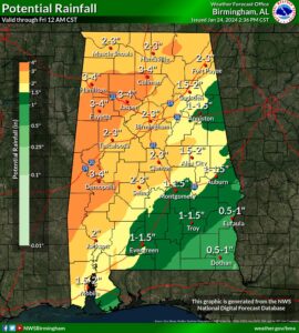
According to the National Weather Service, Heavy rain will continue to slowly move eastward this afternoon, and translate as far south as the I-85 corridor overnight. The repeated rounds of rain will lead to accumulations of 2 to 4 inches with locally higher amounts, which will result in a risk for flooding through tomorrow evening.
Where: Areas near and north of I-85.
When: Through Thursday evening.
Threats: Repeating rounds of heavy rain over the same areas will result in a risk of flooding, especially in poor drainage and urban areas.


You must be logged in to post a comment.