

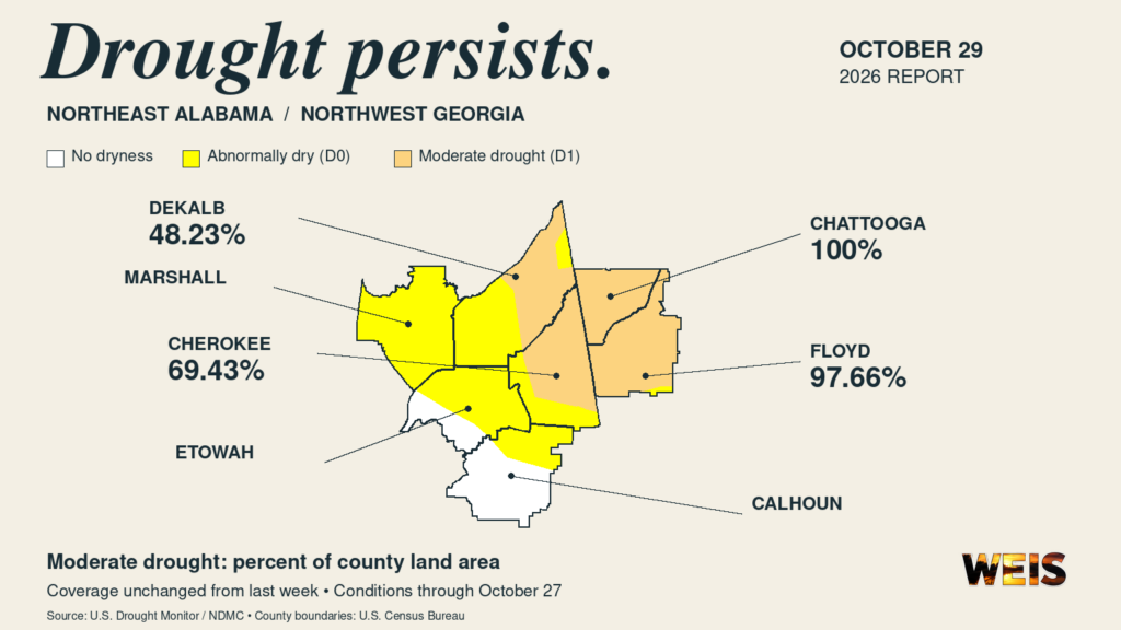
CENTRE– Cherokee County drought conditions remain unchanged in the latest U.S. Drought Monitor, with moderate drought covering 69.43% of the county.
The report, released at 7:30 a.m. Central on Thursday, Oct. 29, also shows widespread drought in neighboring northwest Georgia. It reflects conditions through Tuesday, Oct. 27.
Meanwhile, moderate drought continues across 48.23% of DeKalb County, 97.66% of Floyd County, and all of Chattooga County.
All four percentages match the previous week’s assessment. None of those counties has severe, extreme, or exceptional drought in the new report.
How Local Counties Compare
The Drought Monitor’s official county statistics measure the percentage of county land area in each category. These figures describe geographic coverage, rather than the percentage of residents affected.
| County | Abnormally Dry Only | Moderate Drought |
|---|---|---|
| Cherokee, Alabama | 30.57% | 69.43% |
| DeKalb, Alabama | 51.77% | 48.23% |
| Etowah, Alabama | 70.40% | 0% |
| Calhoun, Alabama | 30.17% | 0% |
| Marshall, Alabama | 99.91% | 0% |
| Floyd, Georgia | 2.34% | 97.66% |
| Chattooga, Georgia | 0% | 100% |
In addition, the abnormally dry percentages in these counties remain unchanged from last week. No county in this seven-county comparison has drought rated severe or worse.
Etowah, Calhoun, and Marshall therefore remain below the moderate drought threshold, despite extensive dryness in parts of the area.
What the Drought Categories Mean
According to the Drought Monitor’s classification guide, moderate drought carries the designation D1. It is the least intense of the four drought categories.
By comparison, D0 means abnormally dry. Such areas may be moving toward drought or recovering from it, but the classification itself does not indicate drought.
The remaining levels are D2, severe drought; D3, extreme drought; and D4, exceptional drought.
However, the map provides a broad assessment. Conditions can vary within a county, and the designation alone does not establish a specific local water shortage.
A Weekly Assessment of Existing Conditions
In its Southeast summary, the Drought Monitor reported little or no precipitation across most of the region during the assessment period. Earlier rainfall limited deterioration in many areas, although some parts of Georgia and neighboring states worsened.
Locally, however, the county figures show persistence rather than an expansion of drought coverage this week.
The Drought Monitor’s explanation of its process says authors consider rainfall, streamflow, reservoir levels, soil moisture, vegetation, and other evidence. They also incorporate observations and feedback from local experts.
Because the map assesses recent conditions, it is not a rainfall forecast. Rain falling after Tuesday’s cutoff would enter a later assessment.
The weekly update also does not itself declare a drought emergency or impose water restrictions. Residents should follow guidance from their water provider and local authorities concerning any conservation measures.
The National Drought Mitigation Center produces the monitor in partnership with USDA, NOAA, and NASA.



You must be logged in to post a comment.