
A slow-moving October nor’easter aimed at the Mid-Atlantic seaboard is expected to produce days of high winds, life-threatening rip currents, beach erosion and coastal flooding from North Carolina up to New Jersey.
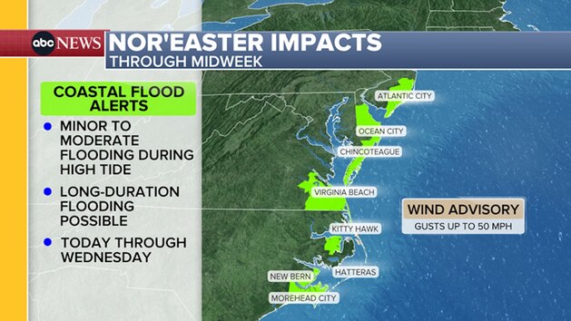
Coastal flood alerts are in effect from Monday through Tuesday in Virginia, Maryland, New Jersey, North Carolina and Delaware.
The long-duration storm is expected to stretch into the middle of this week. The storm is expected to mainly be a wind and wave event, with the bulk of the rain remaining offshore.
Minor to moderate coastal flooding is likely, especially at high tides, in multiple cities including Atlantic City and Virginia Beach.
Wind advisories have also been issued for portions of coastal Virginia and North Carolina, including Virginia Beach and North Carolina’s Northern Outer Banks, Hatteras Island and Ocracoke Island. Sustained northeast winds in these areas are expected to be 25-35 mph, with gusts of up to 50 mph.
Large breaking waves of 9 to 12 feet are possible for parts of the Outer Banks and along the Delmarva Peninsula from Virginia to Delaware through late early Thursday.
Weather conditions are already deteriorating in the Outer Banks and other barrier islands off the North Carolina coast.
Mandatory evacuation orders have been issued for Hatteras Island in North Carolina, creating heavy traffic on Highway 12, according to Dare County, North Carolina, Emergency Management.
“Visitors are not permitted to enter Hatteras Island at this time and will not be allowed to return until the storm system has passed and conditions along N.C. Highway 12 have improved to the point that the roadway is no longer threatened by ocean overwash,” the Dare County Emergency Management said in a statement issued on Sunday.
Copyright © 2026, ABC Audio. All rights reserved.