
No Change to Winter Storm Watch in Latest National Weather Service Update
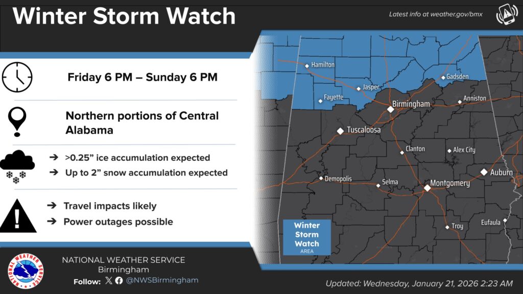
CENTRE — The National Weather Service in Birmingham reports there has been no change to the current Winter Storm Watch area in its most recent forecast update, despite some overnight forecast models shifting the potential impacts farther north.
Forecasters said some model guidance overnight suggested changes in air mass placement that could push potentially hazardous winter weather—including freezing rain, ice, sleet, and snow—north of the previously identified areas. However, due to continued uncertainty and the need to review additional model runs, officials said there is not enough confidence at this time to make changes to the existing watch.
According to the National Weather Service, forecast models could continue to trend northward, or they could shift back south in later runs. Meteorologists emphasized that uncertainty remains high this far in advance, particularly with complex winter weather systems in the Southeast.
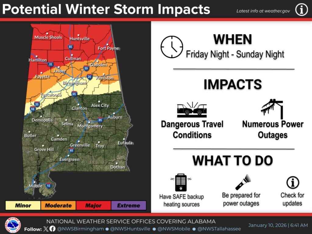
The impact rating has shifted slightly north though
In an explanatory statement, the National Weather Service addressed the uncertainty involved in long-range winter forecasting:
“Let’s talk about the uncertainty…
We have several different models we examine for weather. Each model is initialized differently, putting different weights on different parameters. So when the models run their algorithms, because they initialize differently, we can get widely different results.When models are in agreement (generally), or have consistency, for many days out in advance before a big, impactful system, this tends to lead us to higher confidence. If models, generated differently using different weighting and different algorithms, agree, then surely that means the event will occur….right?
Sometimes.
Every now and then, one of the models picks up data that causes it to produce different output. This could be wonky data that gets ingested and causes something different. Or it could be that the model really is picking up on something in the pattern that the others aren’t catching yet.
Up until last night, the low pressure causing all this rain was expected to be across the state, which would cause plenty of cold air for the rain to change to freezing rain, snow, and sleet. Last night, one of the models starting showing a vastly different solution, and pushed that low much farther north. This would prevent enough cold air from changing the rain to the snow/sleet/freezing rain. This would change the impacts significantly.
We’re not advertising this widely for many reasons:
It JUST changed, so our confidence is low. We would need to see if the other models fall into agreement, or that model moves it’s way back to what it was showing.
If we start advertising ‘little to no impacts’ and then the model changes for the worse, that is MUCH harder to advertise the worsening conditions than to go the other way.
Looking at the environment, there could be enough cooling as the precip falls, or other environmental considerations, that colder temps could be seen, colder than what the models are showing at the surface.
So what can you do? Stay aware of the weather and know that this is a complicated system (winter in AL is by default complicated). We’ll update you with any and all changes. And know we’re watching every data ingestion, every raw data product, sounding, graph, chart, and measurement like a hawk.
If the low moves north and we end up with mostly rain (and maybe some storms), then consider this an exercise in preparation. If the low remains south enough to experience wintry weather, then we’ll have some advance notice.”
Based on the latest information, officials advise residents to continue planning for a worst-case scenario while hoping for more favorable conditions. Forecast outcomes still range from a cold and wet weekend to a significant winter weather event.
WEIS will continue to monitor updates from the National Weather Service in Birmingham and provide the latest information as it becomes available.


You must be logged in to post a comment.