
DO NOT DO ANY OUTDOOR BURNING
RED FLAG WARNING IN EFFECT THROUGH THIS EVENING…
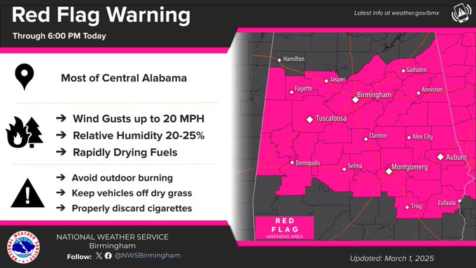
.RED FLAG WARNING IN EFFECT FROM 11 AM THIS MORNING TO 6 PM CST THIS EVENING FOR MUCH OF CENTRAL ALABAMA.
The National Weather Service in Birmingham has issued a Red Flag Warning for gusty winds and low relative humidities, which is in effect from 11 AM this morning to 6 PM CST this evening.
The Following Counties are in the Warned Area
Lamar-Fayette-Walker-Blount-Etowah-Calhoun-Cherokee-Cleburne-Pickens-Tuscaloosa-Jefferson-Shelby-St. Clair-Talladega-Clay-Randolph-Sumter-Greene-Hale-Perry-Bibb-Chilton-Coosa-Tallapoosa-Chambers-Marengo-Dallas-Autauga-Lowndes-Elmore-Montgomery-Macon-Bullock-Lee-Russell-Pike-Barbour-
Persons in these areas can expect the following condition:
WINDS…Northwest 10 to 15 mph, with gusts to 20 mph.
* RELATIVE HUMIDITY…As low as 20 percent.
* IMPACTS…The combination of a dry air mass and windy conditions will result in critical fire weather conditions. Outdoor burning is not recommended.
PRECAUTIONARY/PREPAREDNESS ACTIONS…
A Red Flag Warning means that critical fire weather conditions are either occurring now….or will shortly. A combination of strong winds…low relative humidity…and warm temperatures can contribute to extreme fire behavior.


You must be logged in to post a comment.