Flood Watch
Flood Watch...CORRECTED
National Weather Service Birmingham AL
248 AM CST Tue Jan 23 2024
ALZ011>015-017>020-022>027-030>032-034-232200-
/O.COR.KBMX.FA.A.0001.240124T1800Z-240126T0600Z/
/00000.0.ER.000000T0000Z.000000T0000Z.000000T0000Z.OO/
Marion-Lamar-Fayette-Winston-Walker-Blount-Etowah-Calhoun-
Cherokee-Pickens-Tuscaloosa-Jefferson-Shelby-St. Clair-Talladega-
Sumter-Greene-Hale-Bibb-
Including the cities of Fayette, Double Springs, Gadsden, Hoover,
Eutaw, Centre, Livingston, Greensboro, Columbiana, Oneonta,
Sulligent, Sylacauga, Carrollton, Vernon, Jasper, Moundville,
Tuscaloosa, Alabaster, Pelham, Moody, Talladega, Birmingham,
Anniston, Centreville, Hamilton, and Pell City
248 AM CST Tue Jan 23 2024
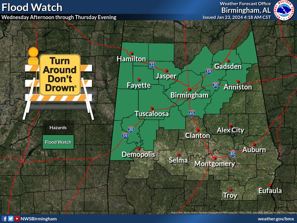
...FLOOD WATCH IN EFFECT FROM WEDNESDAY AFTERNOON THROUGH THURSDAY
EVENING...
* WHAT...Flash flooding caused by excessive rainfall is possible.
* WHERE...The following Central Alabama counties; Bibb, Blount,
Calhoun, Cherokee, Etowah, Fayette, Greene, Hale, Jefferson,
Lamar, Marion, Pickens, Shelby, St. Clair, Sumter, Talladega,
Tuscaloosa, Walker and Winston.
* WHEN...From Wednesday afternoon through Thursday evening.
* IMPACTS...Excessive runoff may result in flooding of rivers,
creeks, streams, and other low-lying and flood-prone locations.
Flooding may occur in poor drainage and urban areas.
* ADDITIONAL DETAILS...
- Showers and thunderstorms are forecast to move into Central
Alabama Wednesday afternoon and persist through Thursday
evening. Locally heavy rainfall is possible due to any slow-
moving or training thunderstorms. 2 to 4 inches of rainfall
is forecast across the watch area, with locally higher
amounts.
- http://www.weather.gov/safety/flood
PRECAUTIONARY/PREPAREDNESS ACTIONS...
You should monitor later forecasts and be alert for possible Flash
Flood Warnings. Those living in areas prone to flooding should be
prepared to take action should flooding develop.
Flood Watch
Flood Watch
National Weather Service Huntsville AL
338 AM CST Tue Jan 23 2024

.Several rounds of rain and thunderstorms are expected across the
Tennessee Valley from Wednesday through late Thursday night. Storm
total rainfall amounts will range from 2.5-3.5 inches, but locally
higher amounts can be expected with thunderstorms. The risk for
flash, areal, and river flooding will be high during this period.

ALZ001>010-016-TNZ076-096-097-232215-
/O.NEW.KHUN.FA.A.0001.240124T1800Z-240126T0600Z/
/00000.0.ER.000000T0000Z.000000T0000Z.000000T0000Z.OO/
Lauderdale-Colbert-Franklin AL-Lawrence-Limestone-Madison-Morgan-
Marshall-Jackson-DeKalb-Cullman-Moore-Lincoln-Franklin TN-
Including the cities of Town Creek, Athens, Fayetteville,
Scottsboro, Winchester, Florence, Cowan, Fort Payne, Sheffield,
Guntersville, Cullman, Sewanee, Lynchburg, Arab, Albertville,
Russellville, Estill Springs, Huntsville, Decatur, Tuscumbia,
Muscle Shoals, Rainsville, Boaz, Red Bay, Moulton, and Decherd
338 AM CST Tue Jan 23 2024

...FLASH FLOOD WATCH IN EFFECT FROM WEDNESDAY AFTERNOON THROUGH
THURSDAY EVENING...

* WHAT...Flash flooding caused by excessive rainfall is possible.

* WHERE...Portions of Alabama, including the following areas,
  Colbert, Cullman, DeKalb, Franklin AL, Jackson, Lauderdale,
  Lawrence, Limestone, Madison, Marshall and Morgan and southern
  middle Tennessee, including the following areas, Franklin TN,
  Lincoln and Moore.

* WHEN...From Wednesday afternoon through late Thursday evening.

* IMPACTS...Excessive runoff may result in flash flooding as well as
  flooding of rivers, creeks, streams, and other low-lying and
  flood-prone locations. Creeks and streams may rise out of their
  banks.

* ADDITIONAL DETAILS...
  - Rainfall amounts between 2.5-3.5 inches are expected across
    the region on Wednesday and Thursday, along with locally
    higher totals.
  - http://www.weather.gov/safety/flood

PRECAUTIONARY/PREPAREDNESS ACTIONS...

You should monitor later forecasts and be prepared to take action
should Flash Flood Warnings be issued.


You must be logged in to post a comment.