
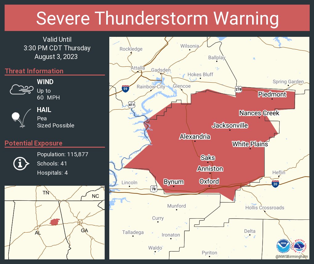
Severe Thunderstorm Warning
Severe Weather Statement
National Weather Service Birmingham AL
254 PM CDT Thu Aug 3 2023

ALC015-032030-
/O.CON.KBMX.SV.W.0311.000000T0000Z-230803T2030Z/
Calhoun AL-
254 PM CDT Thu Aug 3 2023

...A SEVERE THUNDERSTORM WARNING REMAINS IN EFFECT UNTIL 330 PM CDT
FOR CALHOUN COUNTY...

At 254 PM CDT, severe thunderstorms were located along a line
extending from near Piedmont to Saks to near Honda Manufacturing Of
Alabama, moving southeast at 45 mph.

HAZARD...60 mph wind gusts.

SOURCE...Radar indicated.

IMPACT...Expect damage to roofs, siding, and trees.

Locations impacted include...
Anniston, Oxford, Jacksonville, Piedmont, Cobb Town, West End-Cobb
Town, Fort McClellan, Saks, Glencoe, Weaver, Ohatchee, Hobson City,
Blue Mountain, Alexandria, Jacksonville State University, Oxford
Lake, Bynum, Neely Henry Lake, Southside and Choccolocco.

PRECAUTIONARY/PREPAREDNESS ACTIONS...

For your protection move to an interior room on the lowest floor of a
building.

&&

LAT...LON 3389 8553 3388 8564 3380 8559 3377 8564
      3365 8564 3360 8574 3356 8575 3359 8580
      3359 8599 3367 8605 3368 8614 3377 8604
      3384 8607 3391 8597 3391 8590 3394 8590
      3396 8584 3393 8574 3397 8574 3395 8553
TIME...MOT...LOC 1954Z 309DEG 37KT 3393 8569 3373 8583 3367 8610

HAIL THREAT...RADAR INDICATED
MAX HAIL SIZE...<.75 IN
WIND THREAT...RADAR INDICATED
MAX WIND GUST...60 MPH


You must be logged in to post a comment.