
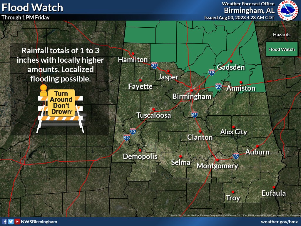
Flood Watch
Flood Watch
National Weather Service Birmingham AL
127 PM CDT Thu Aug 3 2023

ALZ014-017>021-026-041000-
/O.CON.KBMX.FA.A.0006.230803T2100Z-230804T1800Z/
/00000.0.ER.000000T0000Z.000000T0000Z.000000T0000Z.OO/
Winston-Blount-Etowah-Calhoun-Cherokee-Cleburne-St. Clair-
Including the cities of Oneonta, Centre, Double Springs, Gadsden,
Pell City, Heflin, Moody, and Anniston
127 PM CDT Thu Aug 3 2023

...FLOOD WATCH REMAINS IN EFFECT THROUGH FRIDAY AFTERNOON...

* WHAT...Flash flooding caused by excessive rainfall continues to be
  possible.

* WHERE...A portion of central Alabama, including the following
  counties, Blount, Calhoun, Cherokee, Cleburne, Etowah, St. Clair
  and Winston.

* WHEN...Through Friday afternoon.

* IMPACTS...Excessive runoff may result in flooding of rivers,
  creeks, streams, and other low-lying and flood-prone locations.

* ADDITIONAL DETAILS...
  - Multiple rounds of showers and thunderstorms will move across
    northeastern portions of Central Alabama this afternoon
    through mid-day Friday. Total rainfall amounts of 1-2 inches
    with locally higher amounts may result in isolated flash
    flooding.
  - http://www.weather.gov/safety/flood

PRECAUTIONARY/PREPAREDNESS ACTIONS...

You should monitor later forecasts and be prepared to take action
should Flash Flood Warnings be issued.
Flood Watch
Flood Watch
National Weather Service Huntsville AL
341 AM CDT Thu Aug 3 2023

ALZ001>010-016-TNZ076-096-097-032100-
/O.NEW.KHUN.FA.A.0003.230803T1200Z-230804T1800Z/
/00000.0.ER.000000T0000Z.000000T0000Z.000000T0000Z.OO/
Lauderdale-Colbert-Franklin AL-Lawrence-Limestone-Madison-Morgan-
Marshall-Jackson-DeKalb-Cullman-Moore-Lincoln-Franklin TN-
Including the cities of Albertville, Sheffield, Boaz, Scottsboro,
Fayetteville, Lynchburg, Tuscumbia, Cullman, Sewanee, Muscle Shoals,
Decatur, Red Bay, Athens, Fort Payne, Cowan, Huntsville, Arab,
Winchester, Russellville, Decherd, Moulton, Florence, Rainsville,
Guntersville, Estill Springs, and Town Creek
341 AM CDT Thu Aug 3 2023

...FLOOD WATCH IN EFFECT FROM 7 AM CDT THIS MORNING THROUGH FRIDAY
AFTERNOON...

* WHAT...Flooding caused by excessive rainfall is possible.

* WHERE...Portions of norther Alabama and southern middle Tennessee,
  including the following areas, in Alabama, Colbert, Cullman,
  DeKalb, Franklin AL, Jackson, Lauderdale, Lawrence, Limestone,
  Madison, Marshall and Morgan. In southern middle Tennessee,
  Franklin TN, Lincoln and Moore.

* WHEN...From 7 AM CDT this morning through Friday afternoon.

* IMPACTS...Excessive runoff may result in flooding of rivers,
  creeks, streams, and other low-lying and flood-prone locations.

* ADDITIONAL DETAILS...
  - Several consecutive episodes of showers and thunderstorms are
    expected across the Tennessee Valley from today through
    Friday morning. High atmospheric moisture content will exist
    throughout the period, leading to a risk for locally heavy
    rainfall and flooding.
  - http://www.weather.gov/safety/flood

PRECAUTIONARY/PREPAREDNESS ACTIONS...

You should monitor later forecasts and be alert for possible Flood
Warnings. Those living in areas prone to flooding should be prepared
to take action should flooding develop.


You must be logged in to post a comment.