
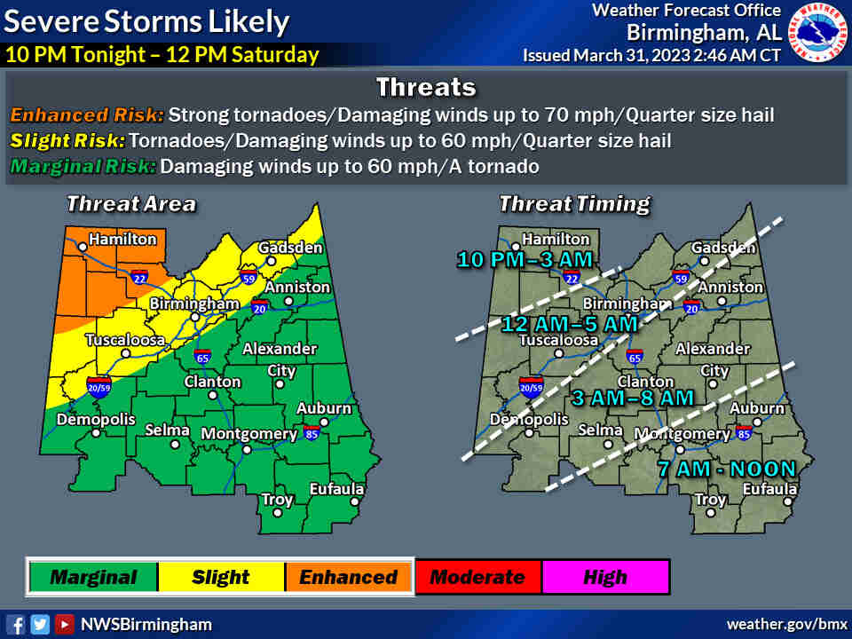
Overview:
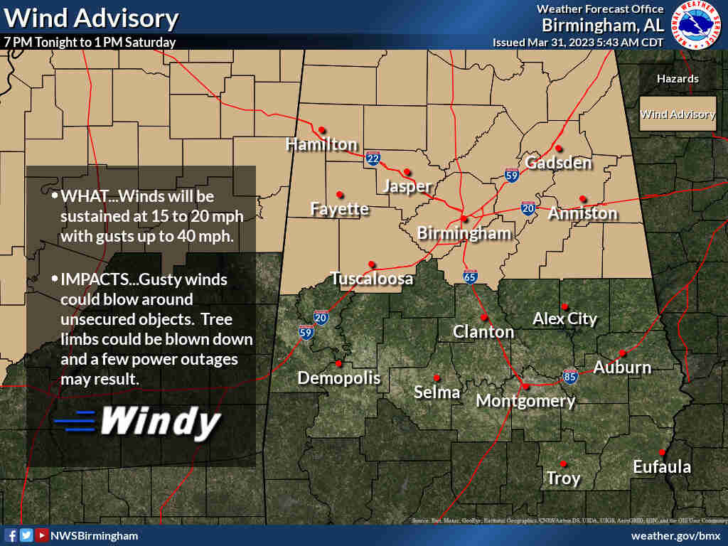
Scattered severe thunderstorms are possible Friday evening and overnight ahead of a line of severe thunderstorms expected to move through the state early Saturday through midday Saturday. A Wind Advisory has been issued for the northern half of the area from 7 PM tonight to 1 PM Saturday. Wind gusts up to 40 mph are possible in this Advisory area.
Changes from previous forecast:
Extended the Marginal Risk to cover the southeast counties, and extended the ending time
Highlights:
Where:
* All of Central AL
When:
* 10 PM Friday – 12 PM Saturday
Threats:
* Strong tornadoes
* Damaging winds up to 70 mph
* Quarter size hail
The northern half of Alabama is in line for another potentially stormy night.
Strong to severe storms and tornadoes will be possible starting late Friday and lasting into Saturday for the northern half of the state as a cold front approaches Alabama. Forecasters cautioned that a few of the tornadoes could be strong (EF-2+).
This round of storms is expected to affect mainly north and north-central Alabama. South Alabama is not expected to have to deal with severe weather on Friday, but a few strong storms will be possible in the southeast part of Alabama on Saturday.
The National Weather Service expects a line of strong to severe storms to move from west to east across the state starting late tonight. A few storms could also develop earlier this evening ahead of the main line.
Since storms could affect Alabama (again) during the overnight hours, it’s important to have a reliable way to get severe weather warnings that can wake you up if needed:
Individual strong to severe storms will be possible as soon as this evening in Alabama, but a line of storms is expected to approach the state later tonight.
In addition to damaging winds from storms it there could also be strong gradient winds outside of storms, according to forecasters. Wind gusts could be as high as 45 mph, and wind advisories have been issued for the northern half of the state for tonight into Saturday morning.
The northern part of Alabama could see non-storm gusty winds later today, and the areas in brown will be under wind advisories.
NOAA’s Storm Prediction Center is maintaining a Level 3 out of 5 risk for severe weather for the northwest corner of Alabama, including places such as Huntsville, Florence, Muscle Shoals, Decatur, Russellville, Jasper and Hamilton.
A Level 3 risk means that numerous severe storms will be possible.
A strip of Alabama from the western border to the northeast corner has a Level 2 risk and could see scattered severe storms. Areas in the Level 2 risk include Birmingham, Gadsden, Fort Payne and Tuscaloosa.
Areas to the south and east, including more of central and part of southwest Alabama, have a Level 1 risk, which means that isolated severe storms will be possible.
Areas in the Level 1 risk area include Anniston, Sylacauga, Centreville and Selma.
Storms are expected to lose steam as they head south and east overnight, but severe weather will be possible into parts of central Alabama through Saturday morning.
Then the Level 1 severe weather risk could last into the day on Saturday for the southeast corner of the state. Here is the severe weather outlook for Saturday:
Isolated severe storms will be possible during the day on Saturday in the areas in dark green.
Calmer weather is expected to follow Saturday’s storms, but another chance for severe weather could materialize on Tuesday, at least for the northern part of Alabama.
The Storm Prediction Center has yet another severe weather risk that includes northwest Alabama for Tuesday. The weather service said the timing could change but as of now it appears storms will be possible from Tuesday night into Wednesday morning.
More storms could affect northern Alabama on Tuesday.


You must be logged in to post a comment.