
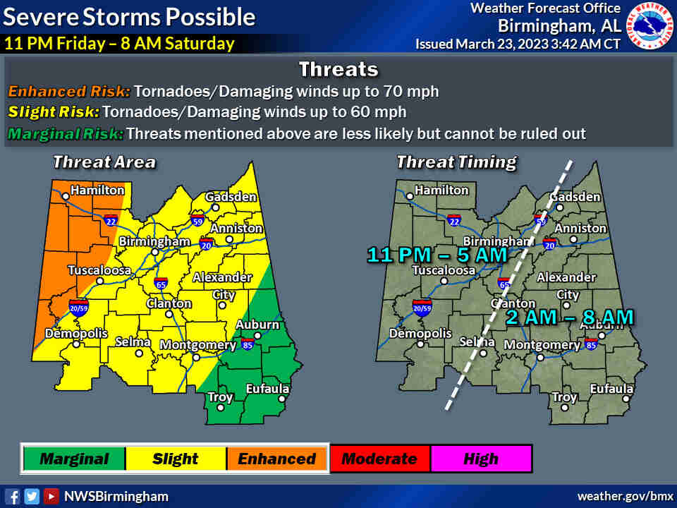
Severe weather is looking more likely across parts of Alabama from Friday night into Saturday morning ahead of a strong cold front. Tornadoes, winds capable of taking down trees and power lines and hail will all be possible as that line of storms moves across the state starting late Friday.
Supercell storms will also be possible ahead of the main line, and those could spawn tornadoes, according to forecasters. Storms could enter western Alabama around 9 p.m. on Friday and roll eastward through the overnight hours, exiting the state on the east side later on Saturday morning.
Alabamians need to ensure they have a reliable way of getting severe weather warnings that will wake them up if storms threaten in the middle of the night.
NOAA’s Storm Prediction Center has added a Level 3 out of 5 — or enhanced — risk for severe weather for parts of north and west Alabama for Friday. A Level 3 risk means numerous severe storms will be possible.
Areas to the east, including the rest of north Alabama and parts of central Alabama and southwest Alabama, will have a Level 2 risk, which means that scattered severe storms will be possible. The rest of the state, except the southeast corner, will have a Level 1 risk, which means that isolated severe storms will be possible.
That Level 1 risk will continue into the day on Saturday for southeast Alabama.
Strong storms and rain look the most likely for north and central Alabama, especially northwest Alabama.
The forecast has more question marks for those in southwest Alabama.
The National Weather Service office in Mobile has said the severe weather threat was more conditional for southwest Alabama. However, if storms do manage to get going then there could be the potential for them to become intense, forecasters said.
Areas northwest of Highway 84 stand the best chance to see stronger storms, the weather service said.

STORM TIMING
Here’s a look at when the National Weather Service is expecting storms to affect Alabama:
The weather service doesn’t expect temperatures to fall off following the Friday-Saturday storms, but that could help set the stage for more storms on Sunday. The frontal boundary that is expected to bring storms on Friday could stall out over south Alabama and then lift back to the north as a warm front on Sunday.
There will be the potential for storms to form in the vicinity or south of that warm front during the afternoon and evening hours on Sunday, according to forecasters.
So far the Storm Prediction Center does not have Alabama in a severe weather risk for Sunday, but forecast trends will continue to be monitored over the weekend.
Calmer weather is expected starting next week.


You must be logged in to post a comment.