
 Hazardous Weather Outlook
National Weather Service Birmingham AL / 3:55 AM CST Wed Dec 14 2022
Including counties Marion-Lamar-Fayette-Winston-Walker-Blount-Etowah-Calhoun-Cherokee- Cleburne-Pickens-Tuscaloosa-Jefferson-Shelby-St. Clair-Talladega-Clay-Randolph-Sumter-Greene-Hale-Perry-Bibb-Chilton-Coosa-Tallapoosa-Chambers-Marengo-Dallas-Autauga-Lowndes-Elmore-Montgomery-Macon-Bullock-Lee-Russell-Pike-and Barbour
This Hazardous Weather Outlook is for the counties served by the National Weather Service office in Birmingham.
 Outlook through Tonight.
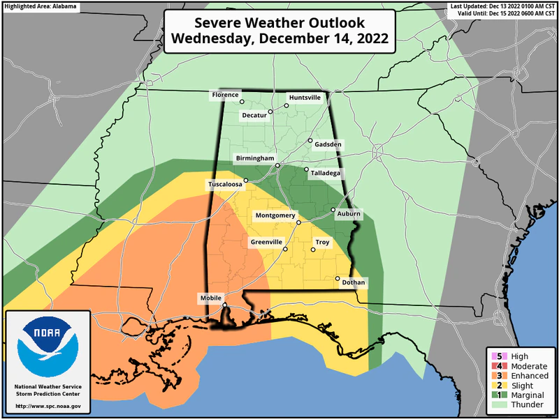
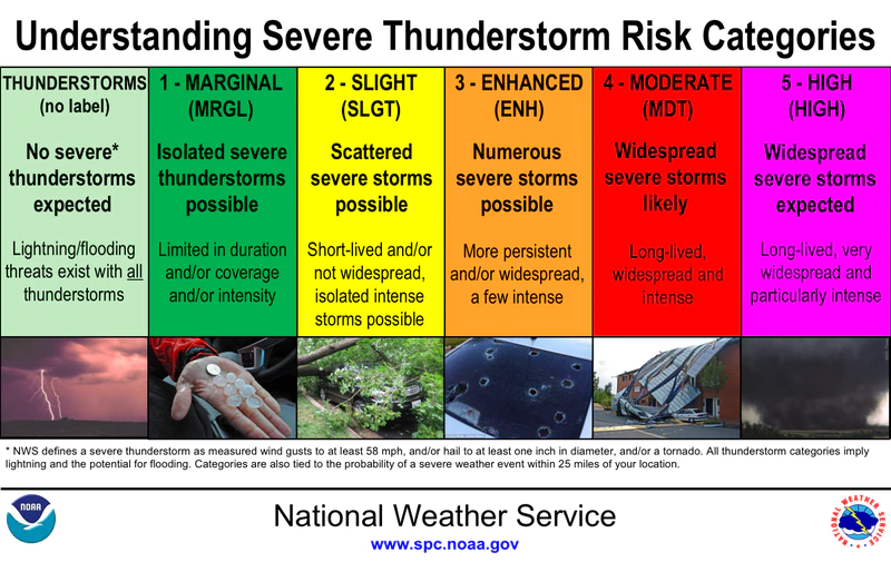
Severe storms will be possible this afternoon through tonight with the highest threat across southern portions of Central Alabama. Tornadoes and damaging winds will be possible.
Heavy rainfall and flash flooding will also be likely today and tonight, generally across the northwest half of Central Alabama.
Wind gusts outside of thunderstorms may approach 35 mph mainly across northern portions of Central Alabama today and tonight.
 Thursday through next Tuesday.
Minor flooding will be possible along the Tombigbee and Lower Black Warrior River basins Thursday through Sunday.
 Flood Watch
National Weather Service Birmingham AL
309 AM CST Wed Dec 14 2022
Marion-Lamar-Fayette-Winston-Walker-Blount-Etowah-Calhoun-Cherokee-Pickens-Tuscaloosa-Jefferson-Shelby-St. Clair-Sumter-Greene-Hale-Bibb-Including the cities of Sulligent, Hoover, Pelham, Double Springs, Fayette, Pell City, Eutaw, Jasper, Oneonta, Alabaster, Centre, Moody, Carrollton, Columbiana, Tuscaloosa, Vernon, Anniston, Greensboro, Gadsden, Hamilton, Birmingham, Centreville, Livingston, and Moundville
FLOOD WATCH REMAINS IN EFFECT THROUGH THIS EVENING (WEDNESDAY)
* WHAT
Flash flooding caused by excessive rainfall is possible. Rainfall totals of 2 to 4 inches are expected with locally higher amounts possible.
* WHERE
A portion of Central Alabama including the following counties, Bibb, Blount, Calhoun, Cherokee, Etowah, Fayette, Greene, Hale, Jefferson, Lamar, Marion, Pickens, Shelby, St. Clair, Sumter, Tuscaloosa, Walker and Winston.
* WHEN
Through this evening.
* IMPACTS
Excessive runoff may result in flooding of rivers, creeks, streams, and other low-lying and flood-prone locations. Creeks and streams may rise out of their banks. Flooding may occur in poor drainage and urban areas.
PRECAUTIONARY/PREPAREDNESS ACTIONS
Be prepared to take action should Flash Flood Warnings be issued.


You must be logged in to post a comment.