Severe storms, tornadoes, hail and some flooding will be possible across portions of Alabama on Tuesday.
According to the National Weather Service – severe thunderstorms could be possible, starting Tuesday morning or afternoon, in west Alabama, and they could last into the overnight hours for those in east Alabama.
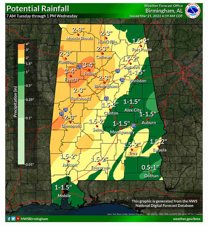
There will be gusty winds during the day that could down tree limbs and power lines and there will be potential for flash flooding, up to four inches of rain will be possible through Wednesday,
Wind advisories and flood watches will possibly be issued for parts of the state
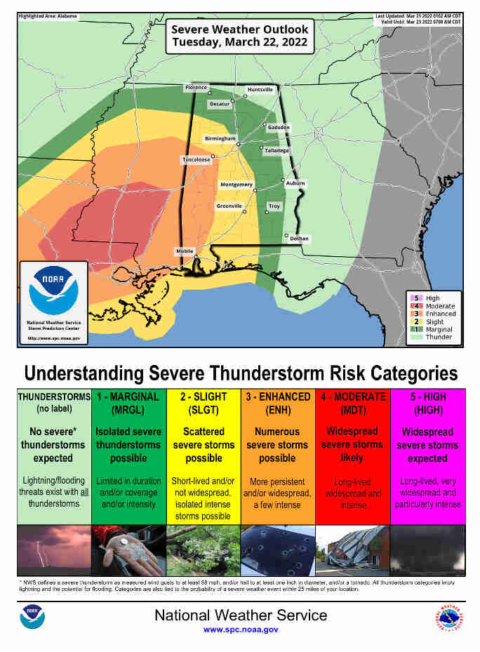
The Storm Prediction Center also has an enhanced risk for severe weather for parts of west Alabama for Tuesday; that’s Level 3 out of 5 and means that numerous severe storms will be possible. That risk area stretches roughly from Tuscaloosa southward to Mobile. A large part of central and south Alabama will have a slight or Level 2 risk, which means that scattered severe storms will be possible.
The rest of Alabama could see storms, but severe weather isn’t expected, and parts of Alabama will have an enhanced risk (that’s a Level 3) for severe weather on Tuesday.
The weather service expects storms to move into Alabama from the west starting on Tuesday. They could arrive in the form of a squall line or a messier storm complex called a mesoscale convective system or MCS. There’s also the potential for supercell storms to develop ahead of the main line – and – those would be watched especially closely for rotation and tornadoes. The weather service in Mobile said those could be possible as early as late Tuesday morning for parts of southwest Alabama.
The weather service isn’t ruling out the possibility of a strong (EF-2+) tornado in the enhanced risk area, in addition to those storms there could be gusty winds across the state – there are additional things to watch along the coast including coastal flooding, high surf and a high risk for rip currents.
Flooding is also a concern. Several inches of rain will be possible in Alabama through Wednesday, with west Alabama forecast to get the most; up to 4 inches of rain will be possible for parts of Alabama through Wednesday afternoon.
The risk for severe storms will shift east into Wednesday – and that Storm Prediction Center has that portion of the state in a severe weather risk. Southeast Alabama will have a Level 2 (slight) risk, and northeast Alabama a Level 1 (marginal) risk
Once these storms move out things will quiet down for the rest of the week, with no rain expected.