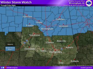
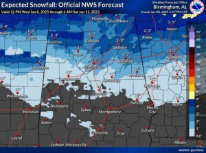
A wintry mix of snow, sleet, rain, and possibly freezing rain will move in from the west after midnight Thursday night. Temperatures at or just below freezing will result in difficult travel conditions for the morning commute, especially across the northern half of Central Alabama. Temperatures will warm a couple degrees above freezing during the day, with precipitation changing over to rain across much of the area by midday. However, areas in far northern and northeastern Central Alabama will stay a bit cooler, keeping at least some potential for wintry precipitation continuing into Friday afternoon and evening there. Small fluctuations in temperatures at the ground and above the surface, as well as the intensity of the precipitation, will play a large role in precipitation type and accumulations and associated impacts. The greatest concern for significant impacts will be in the Winter Storm Watch area, where heavy wintry precipitation could quickly accumulate, especially during the morning commute when temperatures will be near or below freezing. Look for potential upgrades to Winter Storm Warnings and Winter Weather Advisories overnight, including the need for a Winter Weather Advisory south of the current Winter Storm Watch area.

Changes from previous forecast: Minor northward adjustments to accumulations and the southern extent of the Limited impact area.
What: Snow and sleet accumulations of 2 to 4 inches in the Winter Storm Watch area with locally higher amounts. Accumulations of less than 2 inches in areas south of the Winter Storm Watch area and north of Highway 80.
- Brief periods of freezing rain may result in ice accumulations less than 0.05″.

Where: Areas generally north of Highway 80 and Interstate 85, with the highest accumulations north of I-20.When: After midnight Thursday night, lasting through around midday Friday. The exception will be far northern and northeastern portions of Central Alabama where wintry precipitation may linger into Friday evening.
Impacts: Travel conditions may become difficult to dangerous for areas in the Elevated and Significant impact areas, especially Friday morning. Slick spots may develop on area roadways, especially bridges and overpasses north of Highway 80 and Interstate 85.


