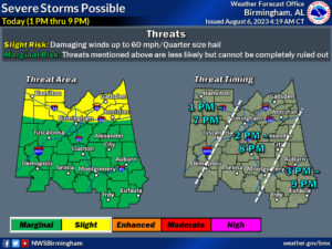
Our active summertime pattern will continue, with rounds of strong to severe storms expected each day through Tuesday. A more organized severe weather risk is possible on Monday. Extreme heat will also be a concern today and once again on Monday before storms arrive.
Changes from previous forecast:
- A Slight Risk of severe storms has been added for today across northern counties of Central Alabama.
- The Slight Risk for Monday has been expanded to include much of Central Alabama.
- An Excessive Heat Warning has been issued for southern and southwest counties, where the heat index could rise above 110° this afternoon.
Highlights:
Severe Today:
- Where: All of Central Alabama, best chances north within the Slight Risk area
- When: 1pm through 9pm
- Threats: Damaging straight-line winds and quarter size hail
Heat Today:
- Where: Most of Central Alabama
- When: Through 9pm tonight
- Impacts: Heat index values are expected to range from 105° to over 110° this afternoon, with highest values expected across southern and southwest counties. Exposure to those conditions for a prolonged period of time may cause heat related illnesses.
Severe Monday:
- Where: All of Central Alabama
- When: 1pm through 10pm
- Threats: Damaging straight-line winds and quarter size hail
Severe Tuesday:
- Where: Southern half of Central Alabama
- When: 1pm through 9pm
- Threats: Damaging straight-line winds up to 60mph


