
National Weather Service Upgrades Severe Weather Risk for Central Alabama
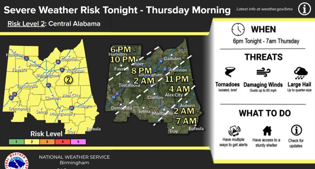
BIRMINGHAM — The National Weather Service in Birmingham has upgraded the severe weather outlook for much of Alabama ahead of a line of storms expected to move through the state late Wednesday night and early Thursday morning.
The entire central portion of Alabama is now under a Slight Risk (Level 2 of 5) for severe weather, according to the latest forecast update. Forecasters say conditions could support strong to severe thunderstorms capable of producing several hazards across the region.
Storms are expected to develop and move across the state between 6 p.m. Wednesday and 7 a.m. Thursday. Across the Northeast Alabama Areas, the primary window for severe weather is expected to occur between 8 p.m. and 2 a.m.
Meteorologists warn the strongest storms could bring damaging winds of up to 60 miles per hour, which may be capable of downing trees and power lines. The system could also produce brief and isolated tornadoes as well as large hail up to the size of a quarter.

In addition to the severe storm threats, forecasters say localized flooding may occur in areas that receive heavy rainfall over a short period of time.
Emergency officials encourage residents to stay weather aware Wednesday evening and overnight, monitor forecasts for updates, and have a reliable way to receive weather alerts while sleeping.
The National Weather Service says additional updates will be issued as the storm system approaches and forecast details become clearer.


You must be logged in to post a comment.