
Cherokee County Officials Review Improving but Ongoing Winter Weather Threat
Latest Information from the National Weather Service in Birmingham

CENTRE — The Cherokee County Emergency Management Agency hosted a winter weather planning meeting Thursday morning, January 22, at the EMA offices inside the Cherokee County Administrative Building, bringing together local government leaders, emergency responders, utility representatives, and county department heads to review the latest forecast and preparedness efforts ahead of the weekend weather system.
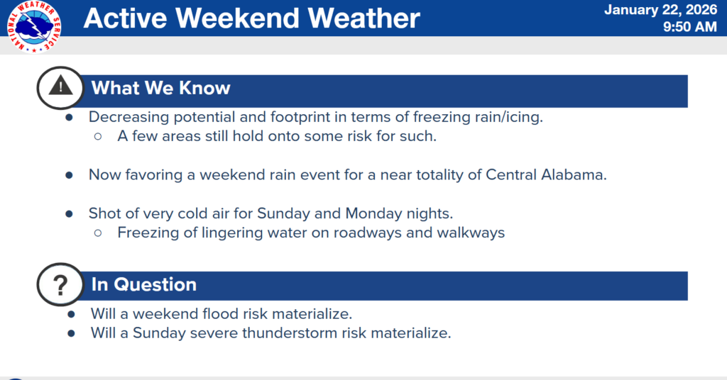
The meeting began with a live webinar briefing from the National Weather Service in Birmingham, where forecasters provided updated guidance on the approaching system. According to the NWS, recent forecast models show a decreasing trend in freezing rain and ice potential across much of Central Alabama, continuing an improving pattern that had already begun to emerge in earlier forecasts.
Meteorologists emphasized that, based on current data, the situation is not worsening and continues to trend slightly better overall. However, they cautioned that some areas — including Cherokee County — still show the potential for problematic icing and freezing rain, particularly on the back side of the system as colder air moves in.
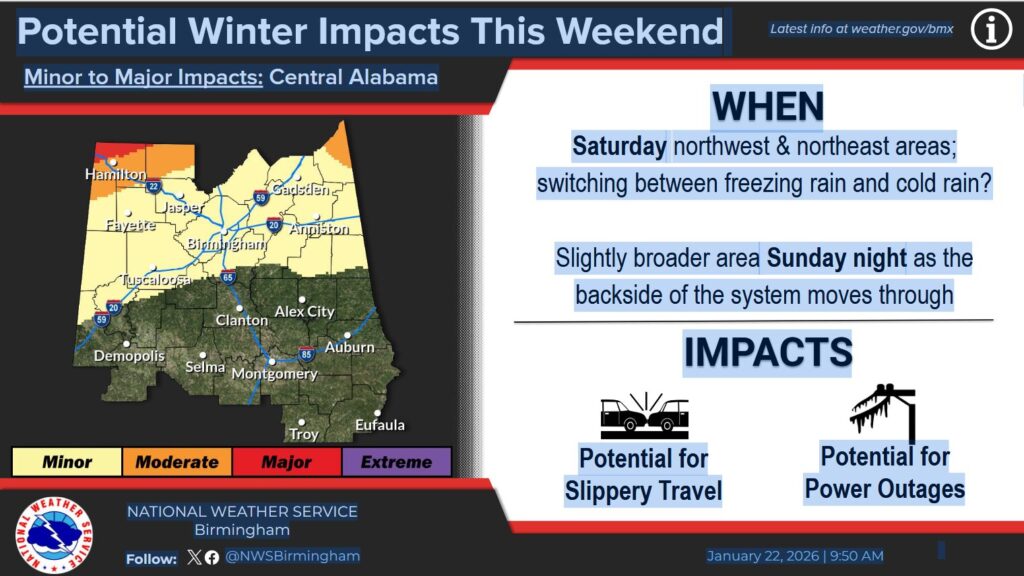
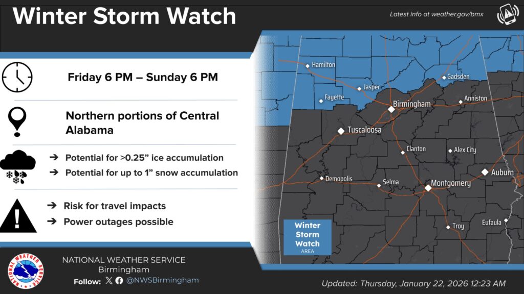
While the greatest concern for significant ice accumulation remains focused on the northwestern counties of Alabama, models continue to indicate the possibility of freezing rain and ice formation in parts of Cherokee County over the weekend. No changes have been made to the existing Winter Storm Watch, as forecasters continue to monitor how the system evolves.
For much of Central Alabama, the primary issue is expected to be heavy rainfall. The National Weather Service said it will be monitoring for localized minor flooding in some areas, as well as the potential for strong to possibly severe thunderstorms, mainly on Sunday. The tornado threat is expected to remain low at this time.
Saturday morning, forecasters expect the main threat of freezing rain and ice to remain northwest of Cherokee County, though they stressed it cannot be ruled out entirely. Much will depend on how far north warmer air from the south advances and how far south colder air holds. Those details should become clearer as higher-resolution forecast models become available closer to the event.
Saturday night, showers are expected across the WEIS listening area. Forecasters noted that if colder air from the Appalachian region pushes farther south than expected, conditions in Cherokee County could become more favorable for freezing rain and ice. If warmer temperatures dominate, the area would instead see periods of moderate to heavy rainfall.
On Sunday, the National Weather Service will continue to watch for the potential development of unstable air moving north from the Gulf of Mexico. If that occurs, it could lead to thunderstorms, with a limited chance that a few storms could reach severe levels. In Cherokee County, there is also the possibility that rain could briefly transition to a wintry mix at times, depending on temperature fluctuations.
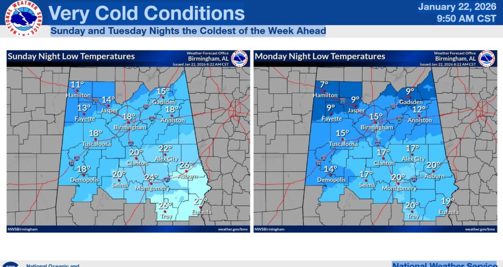
Sunday night into Monday morning remains a key concern. Frigid air is expected to move into the region, with temperatures potentially dropping into the single digits in northeastern Alabama. Combined with gusty winds, conditions could feel dangerously cold. Even if minimal ice accumulation occurs during the storm, any standing water or moisture is likely to freeze, creating black ice and hazardous driving conditions. The NWS advised residents to plan for icy road conditions during that time frame.
Following the weather briefing, Cherokee County EMA Director Shawn Rogers addressed local preparedness efforts. Rogers said that despite the improving forecast, the EMA will continue to prepare for the possibility of hazardous icing conditions, noting that the storm track could still shift southward.

He said winter precipitation and freezing rain are still expected in some capacity, though the exact amounts remain difficult to determine. Representatives from local emergency agencies, Cherokee Electric, county leadership, and municipalities across Cherokee County also shared updates, indicating they are continuing preparations under a “prepare for the worst, hope for the best” approach.
Officials encouraged residents to take the same mindset. While the overall forecast has improved somewhat, the risk of hazardous winter weather has not been eliminated.
The Cherokee County Emergency Management Agency and WEIS Radio will continue to closely monitor forecast updates and provide timely information as conditions and forecasts change throughout the event.


You must be logged in to post a comment.