(NEW YORK) — Devastating wildfires, flooding and extreme heat events took place over the past year, several resulting in mass fatalities, with experts linking some of the worst events to human-amplified climate change.
These are the biggest weather stories of the year:
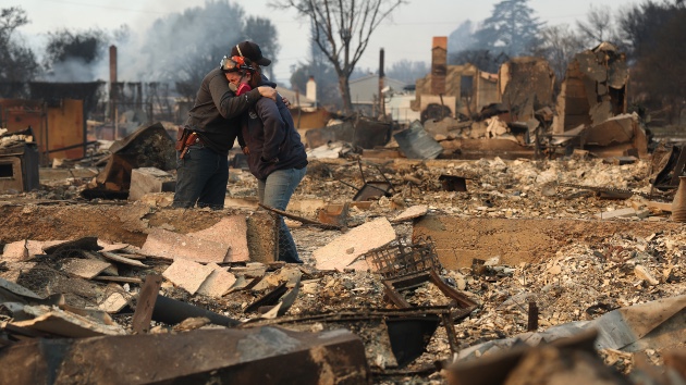
Los Angeles wildfires
Multiple wildfires that sparked in Los Angeles at the beginning of the year spread quickly and burned for weeks, destroying more than 16,000 structures and killing dozens of people.
Fueled by severe drought conditions and Santa Ana winds, the Palisades and Eaton fires both erupted on Jan. 7, eventually spreading more than 37,000 acres over the course of 24 days.
At one point, five wildfires — including the Hurst, Woodley and Lidia fires — were burning through Ventura and Los Angeles counties, according to officials.
Hydroclimate whiplash — the rapid shift between wet and dry conditions — likely contributed to the severity of the wildfires burning in Southern California.
In recent years, parts of the state shifted from a major drought to an extended period of above-average precipitation that allowed for abundant vegetation growth. After that, a stretch of intense, record-breaking heat dried out much of that vegetation and provided ample fuel for large and fast-growing wildfires.
Once the fires were sparked, an exceptionally strong mountain wave wind event, with northerly 80 to 100 mph gusts, spread the fires rapidly through densely populated neighborhoods in Los Angeles.
Among the neighborhoods heavily impacted were the Pacific Palisades, Topanga, Malibu and Altadena.
Celebrities including Billy Crystal, Paris Hilton, Mandy Moore and Eugene Levy were among the residents who lost their homes in the wildfires.
While wildfires are a natural and necessary part of Earth’s cycle, climate change and other more direct human influences have increased their likelihood, research shows.
Texas floods
Extreme flooding that occurred this year in a region in Texas known as “Flash Flood Alley” quickly turned to tragedy when it inundated a popular campground site.
In the early morning hours of July 3, torrential rains turned the Guadalupe River in Kerr County into a raging wall of water, causing the river to rise 26 feet in less than an hour. In some spots, rainfall rates of 2 to 4 inches per hour were measured.
Campsites along the river were filled with campers for the 4th of July weekend, including Camp Mystic, one of the hardest-hit sites.
The flash flooding killed more than 130 people, 36 of whom were children, according to officials.
Texas Hill Country is often colloquially referred to as “Flash Flood Alley” because the weather and landscape in the south-central Texas region have a tendency to produce rapid flood events, according to the Texas Water Resources Institute (TWRI). The “alley” stretches from Dallas to San Antonio and encompasses the Colorado and Guadalupe River basins.
The region’s steep terrain, shallow soil and repeated high rainfall events make it one of the most flood-prone regions in the country.
Drought also played a role in the severity of the event. Severe to exceptional drought conditions were prevalent for much of south-central Texas when the downpours came, making areas more susceptible to flash flooding because the soil could not absorb rainfall as efficiently.
Climate change is likely to make extreme weather events, like the flash flooding in Texas, occur more intensely and frequently, climate scientists told ABC News in July in the aftermath of the floods.
Deadly tornado outbreak in the South
Tornado outbreaks in Kentucky, Missouri and Virginia in mid-May killed at least 28 people, according to officials.
Strong supercell storms spurred tornado activity, tearing roofs off homes and causing several buildings to collapse.
In Missouri, St. Louis was particularly hard hit when an EF-3 tornado with 140 mph winds ripped through neighborhoods.
The first EF-5 tornado in the U.S. in over a decade also occurred this year.
On June 20, a monster tornado with peak winds topping 210 mph hit Enderlin, North Dakota, tipping several fully-loaded grain hopper cars and lofting tanker cars, including one empty tanker car that was tossed more than 475 feet, according to the National Weather Service.
There was also extensive tree damage throughout the entire Maple River valley, with only stubs of large branches or large trunks remaining and debarking with a “sandpapering” effect prevalent, officials said.
While the EF-5 tornado mostly struck a rural area, three people died as a result, according to the NWS.
No hurricanes made landfall in the US
The 2025 Atlantic hurricane season proved to be consequential, even though no hurricanes made landfall in the U.S for the first time since 2015.
Three Category 5 hurricanes formed during this past hurricane season, the second-most on record in the Atlantic basin. The only other season with more Category 5 storms was in 2005, when there were four Category 5 storms.
A combination of favorable conditions and a bit of luck helped the U.S. avoid a landfalling hurricane.
Prevailing winds and weather patterns steered storms away from the coast, and many variables aligned at the right times, keeping hurricanes from making landfall. Persistent dry air and other unfavorable atmospheric conditions hindered storm development during a historically busy timeframe.
Many of the storms that did form followed a similar path, curving away from the U.S. coastline and toward Bermuda. An unusually persistent upper-level trough, or area of lower pressure, sat over the Eastern U.S. throughout much of the season, bringing seasonably mild temperatures by late summer. The recurring trough frequently pushed the jet stream south, helping curve storms northward parallel to the East Coast and then out to sea, following the prevailing west to east wind pattern.
The trough also weakened the western side of the Bermuda High; the dominant high-pressure system located over the Atlantic Ocean that usually helps steer weather systems. When the Bermuda High is strong, storms are pushed farther west toward the East Coast and the Gulf. However, when it is weaker, they tend to turn northward earlier. This season, the weakened Bermuda High, combined with a dip in the jet stream, deflected storms away from land.
The Fujiwhara effect, a rare occurrence in the Atlantic basin, also helped keep Hurricanes Imelda and Humberto away from the U.S. as they were churning through the Western Atlantic at the same time. The Fujiwhara effect occurs when two tropical cyclones within several hundred miles of each other begin to interact and rotate around a common midpoint
Although no hurricanes made landfall in the U.S. in 2025, Hurricane Melissa became one of the most powerful hurricanes on record to make landfall in the Atlantic basin, ranking with Hurricane Dorian (2019) and the “Labor Day” hurricane (1935) for the strongest sustained winds at landfall.
Hurricane Melissa devastated the island of Jamaica, destroying entire communities, and killed dozens of people.
Human-amplified climate change is expected to influence tropical activity in the coming decades. While the total number of tropical cyclones is expected to remain steady or even decrease slightly, the storms that do form are likely to be more intense, according to climate scientists.
Global warming has led to substantial ocean warming, which fuels hurricane intensification. More than 90% of the excess heat trapped by greenhouse gases has been absorbed by the oceans, creating conditions that favor rapid intensification and stronger peak winds. As a result, more storms are reaching major hurricane strength compared to past decades, the latest research shows.
The changing climate is also amplifying the indirect effects of tropical systems that remain well offshore, making coastal areas more vulnerable. Sea level rise and more intense storms increase the risks of flooding, erosion, and shoreline change, according to the federal government’s Fifth National Climate Assessment.
Record heat in Europe
Major heat waves across southern Europe over the summer pushed temperatures passed triple digits in many major cities.
Severe heat waves were recorded in Italy, Greece, Spain and Portugal at the end of June and beginning of July.
The heat was so severe that outdoor work activities were banned in several regions in Italy.
On July 1, the Eiffel Tower in Paris was closed as temperatures topped 101 degrees Fahrenheit.
In Portugal, where two-thirds of the country was on alert for high heat and wildfires, temperatures reached 107 degrees Fahrenheit. Similar temperatures were recorded in Seville, Spain.
In Athens, a large wildfire broke out and was fueled by strong winds, forcing evacuations and road closures near the ancient Temple of Poseidon.
Multiple fatalities occurred, and tourists were advised by local governments to alter their plans as a result of the heat.
Climate scientists warn that extreme heat will become more commonplace across southern Europe as a result of global warming.
Europe is fastest-warming continent on planet, heating up twice as much as the global average since the 1980s, according to a 2023 report by Copernicus, European Union’s climate change service, and the World Meteorological Organization.
There is high confidence in the connection between human-amplified climate change and extreme heat events, research has shown. The attribution of climate change to extreme heat has the strongest connection and highest confidence compared to all other weather events.
ABC News’ Weather and Climate Unit contributed to this report.
Copyright © 2025, ABC Audio. All rights reserved.