Severe Storm Risk Possible Sunday Night Across Central Alabama
The National Weather Service in Birmingham is advising residents across Central Alabama to monitor the weather closely as the potential for severe storms develops Sunday night into early Monday morning.
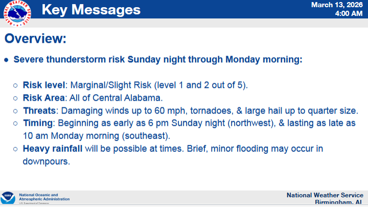
According to forecasters, a marginal to slight risk of severe weather, classified as Level 1 and Level 2 out of 5, has been introduced for the region. The risk area includes all of Central Alabama.
Storms could begin developing as early as 6 p.m. Sunday evening in northwest portions of the state, with activity expected to spread southeastward through the overnight hours. The threat could continue until around 10 a.m. Monday morning in parts of the region.
The National Weather Service says all modes of severe weather will be possible, including damaging winds up to 60 miles per hour, isolated tornadoes, and large hail up to quarter size.
Forecasters also note that periods of heavy rainfall may accompany the storms. While widespread flooding is not expected, brief minor flooding could occur in areas that receive heavier downpours.
Meteorologists say the exact timing and storm intensity will become clearer with additional forecast updates, including a more refined timeline expected with the Day 2 outlook.
Residents are encouraged to stay weather-aware Sunday night and ensure they have multiple ways to receive warnings should severe weather develop.