Cold Weather Advisory, Wind Advisory, Extreme Cold Warning
URGENT – WEATHER MESSAGE
National Weather Service Birmingham AL
1053 AM CST Fri Jan 30 2026
…COLD WEATHER ADVISORY REMAINS IN EFFECT FROM MIDNIGHT TONIGHT TO NOON CST SATURDAY…
…WIND ADVISORY IN EFFECT FROM 2 AM TO 9 PM CST SATURDAY…
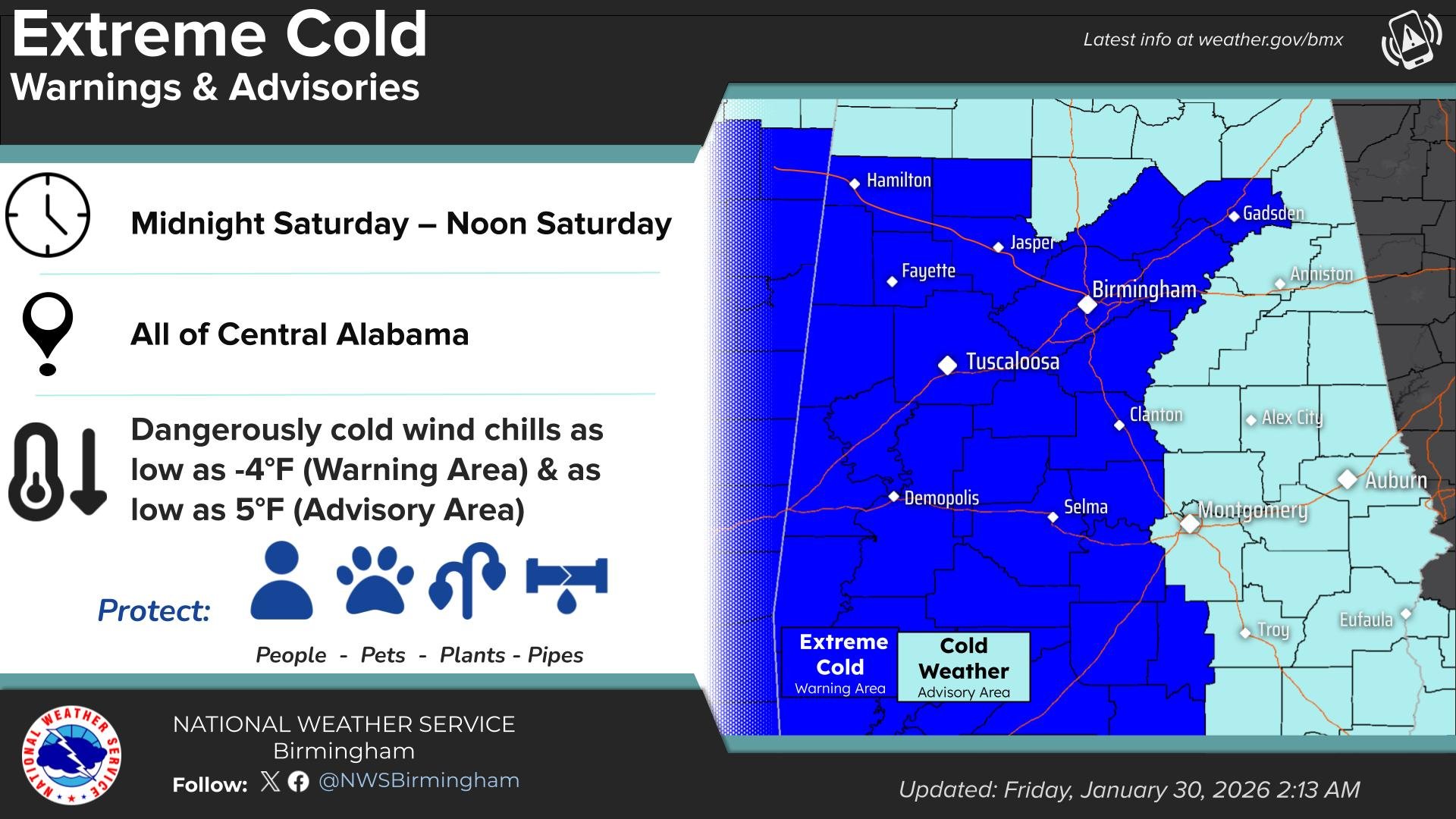
…EXTREME COLD WARNING IN EFFECT FROM NOON SATURDAY TO NOON CST SUNDAY…
* WHAT…For the Cold Weather Advisory, very cold wind chills as low as 4 above expected. For the Wind Advisory, northwest winds 15 to
25 mph with gusts up to 40 mph expected. For the Extreme Cold Warning, dangerously cold wind chills below 5 degrees are expected.
* WHERE…Barbour, Bullock, Calhoun, Chambers, Cherokee, Clay, Cleburne, Coosa, Elmore, Lee, Macon, Montgomery, Pike, Randolph, Russell, Talladega, and Tallapoosa Counties.
* WHEN…For the Cold Weather Advisory, from midnight tonight to noon CST Saturday. For the Wind Advisory, from 2 AM to 9 PM CST Saturday. For the Extreme Cold Warning, from noon Saturday to noon CST Sunday.
* IMPACTS…Gusty winds will blow around unsecured objects. Trees could be blown down and a few power outages may result. Frostbite and hypothermia will occur if unprotected skin is exposed to these temperatures. An extended period of subfreezing temperatures could cause pipes to burst.
PRECAUTIONARY/PREPAREDNESS ACTIONS…
Winds this strong can make driving difficult, especially for high profile vehicles. Use extra caution.
Secure outdoor objects.
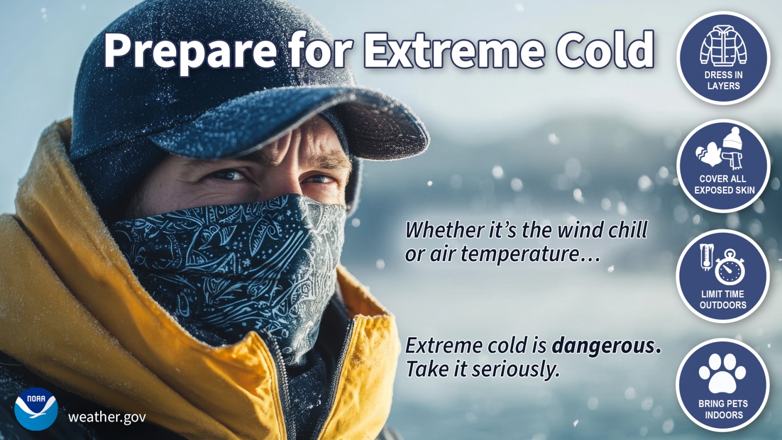
Dress in layers including a hat, face mask, and gloves if you must go outside.
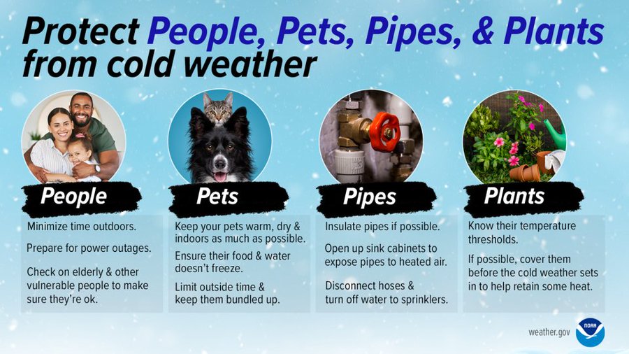
Keep pets indoors as much as possible.
Make frequent checks on older family, friends, and neighbors. Ensure portable heaters are used correctly. Do not use generators or grills inside.
To prevent freezing and possible bursting of pipes they should be wrapped, drained, or allowed to drip slowly.
Use caution while traveling outside. Wear appropriate clothing, a hat, and gloves.
Extreme Cold Warning, Wind Advisory
URGENT – WEATHER MESSAGE
National Weather Service Birmingham AL
1053 AM CST Fri Jan 30 2026
…EXTREME COLD WARNING NOW IN EFFECT FROM MIDNIGHT TONIGHT TO NOON
CST SUNDAY…
…WIND ADVISORY IN EFFECT FROM 2 AM TO 9 PM CST SATURDAY…
* WHAT…For the Extreme Cold Warning, dangerously cold wind chills below zero are expected. For the Wind Advisory, northwest winds 15 to 25 mph with gusts up to 40 mph expected.
* WHERE…Autauga, Bibb, Blount, Chilton, Dallas, Etowah, Fayette, Greene, Hale, Jefferson, Lamar, Lowndes, Marengo, Marion, Perry, Pickens, Shelby, St. Clair, Sumter, Tuscaloosa, Walker, and Winston Counties.
* WHEN…For the Extreme Cold Warning, from midnight tonight to noon CST Sunday. For the Wind Advisory, from 2 AM to 9 PM CST Saturday.
* IMPACTS…Gusty winds will blow around unsecured objects. Trees could be blown down and a few power outages may result. Frostbite and hypothermia will occur if unprotected skin is exposed to these temperatures. An extended period of subfreezing temperatures could cause pipes to burst.
PRECAUTIONARY/PREPAREDNESS ACTIONS…
Winds this strong can make driving difficult, especially for high profile vehicles. Use extra caution.
Secure outdoor objects.
Dress in layers including a hat, face mask, and gloves if you must go outside.
Keep pets indoors as much as possible.
Make frequent checks on older family, friends, and neighbors. Ensure portable heaters are used correctly. Do not use generators or grills inside.
To prevent freezing and possible bursting of pipes they should be wrapped, drained, or allowed to drip slowly.
Cold Weather Advisory
URGENT – WEATHER MESSAGE
National Weather Service Huntsville AL
1059 AM CST Fri Jan 30 2026
Lauderdale-Colbert-Franklin AL-Lawrence-Limestone-Madison-Morgan-Marshall-Jackson-DeKalb-Cullman-Moore-Lincoln-Franklin TN.
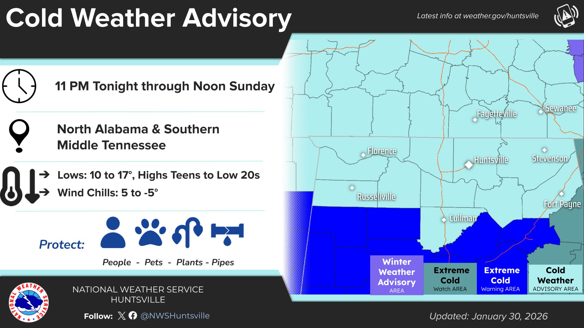
…COLD WEATHER ADVISORY REMAINS IN EFFECT FROM 11 PM THIS EVENING TO NOON CST SUNDAY…
* WHAT…Very cold wind chills from 4 below zero 5 above zero are expected.
* WHERE…All of north Alabama and southern middle Tennessee.
* WHEN…From 11 PM this evening to noon CST Sunday.
* IMPACTS…Frostbite and hypothermia will occur if unprotected skin is exposed to these temperatures.
PRECAUTIONARY/PREPAREDNESS ACTIONS…
Use caution while traveling outside. Wear appropriate clothing, a hat, and gloves.
If you do not have heat in your home or lack shelter, you can call 211 for assistance locating appropriate shelter from the cold.
Stay with WEIS 100.5 FM, 990 AM, and the WEIS Radio app for all the latest weather updates!