(NEW YORK) — Hurricane Melissa made landfall in Jamaica on Tuesday afternoon as a Category 5 hurricane — one of the most powerful hurricane landfalls on record in the Atlantic basin.
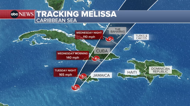
Here is Melissa’s projected path:
The hurricane-force winds began in western Jamaica on Tuesday morning and will last until the evening.
Around 1 p.m. ET, Melissa made landfall in southwestern Jamaica near New Hope with estimated maximum sustained winds of 185 mph. This is considered an extremely dangerous and life-threatening situation; people in Jamaica are urged to shelter in place.
The worst storm surge will be on the western half of the island, where 9 to 13 feet of surge will inundate the coast. On the northwest side of the island, the Montego Bay area could see 2 to 4 feet of storm surge above ground level. The capital city of Kingston will see damaging storm surge, but not the worst.
Heavy rain will inundate the entire island, with totals of 15 to 30 inches expected, and some areas seeing up to 40 inches. The rain will likely spark catastrophic flash flooding and landslides.
Jamaicans should be prepared for extensive infrastructure damage and long-lasting power outages.
Southeast Cuba will feel hurricane-force winds Tuesday night through Wednesday morning. Cuba is forecast to see 7 to 11 feet of storm surge, up to 25 inches of rain, and potentially landslides and catastrophic flash flooding.
The southeast Bahamas and Turks and Caicos will feel the impacts of Hurricane Melissa on Wednesday. Four to 6 feet of storms surge is expected along with 5 to 10 inches of rain.
Melissa will still be a hurricane by the time it passes near Bermuda on Friday morning.
Copyright © 2025, ABC Audio. All rights reserved.