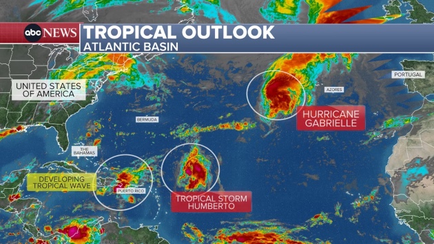
(NEW YORK) — The tropics are heating up, with Hurricane Gabrielle and Tropical Storm Humberto both churning in the Atlantic as well as a new system that could strengthen and possibly impact the Southeast next week.
Hurricane warnings are in place over Portugal’s Azores islands, where Hurricane Gabrielle is expected to bring damaging winds, coastal flooding and destructive waves Thursday night and Friday. The remnants of Gabrielle are expected to reach Portugal and western Spain on Sunday.
Meanwhile, slow-growing Tropical Storm Humberto has formed in the Atlantic. Humberto might strengthen into a hurricane this weekend and could potentially strengthen even further into a major hurricane — Category 3 or higher — early next week.
Humberto is expected to take a similar path to last month’s Hurricane Erin, moving between Bermuda and the U.S. East Coast over the first half of next week.
Another tropical wave has a strong chance to become a tropical depression on Friday and may quickly strengthen into a tropical storm named Imelda.
The system is currently bringing heavy rain and gusty winds to Puerto Rico and the Dominican Republic, and when it passes over or near the Bahamas this weekend, it may strengthen further into a hurricane.
Because this system hasn’t formed yet, those along the Southeast coast should monitor the forecasts over the next 48 hours.
While a landfall is unlikely, it cannot be completely ruled out.
Regardless, rain and at least some wind from this system are expected in the Southeast — especially the Carolinas — on Monday and Tuesday, potentially causing flooding.
Copyright © 2025, ABC Audio. All rights reserved.