(NEW YORK) — Hurricane Erin, now a Category 2 hurricane, has prompted a tropical storm watch for North Carolina’s Outer Banks and is expected to bring dangerous waves and rip currents to beaches along the East Coast.
Here’s the latest forecast:
The Outer Banks
While the storm won’t make landfall on the East Coast, it has prompted mandatory evacuations for some Outer Banks residents and visitors.
The Outer Banks is forecast to get heavy rain Wednesday night into Thursday and winds over 40 mph.
A storm surge watch and a high surf advisory have been issued, with destructive, large breaking waves up to 20 feet in the forecast. Coastal damage is likely from large waves destroying protective dunes. The flooding will also extend inland, likely impacting roads.
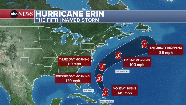
Tracking Erin
Dangerous rip currents and large waves are forecast for the East Coast through Friday.
The popular beach towns of Rehoboth Beach, Delaware, and Wildwood, New Jersey, banned swimming on Monday due to the rough surf.
More than 50 people were rescued from the ocean at Wrightsville Beach, North Carolina, on Monday local officials said, and no swimming is recommended at Wrightsville Beach from Tuesday though Friday.
On Tuesday, waves will pick up along the East Coast, with Florida to the Outer Banks facing the worst conditions.
By Wednesday, the waves will increase along the Carolinas as Erin makes its closest pass to the Outer Banks Wednesday night into Thursday.
On Thursday, the high surf will arrive to beaches in the Mid-Atlantic and New England. A high surf advisory is also posted for portions of New Jersey, Long Island and Massachusetts.
Copyright © 2025, ABC Audio. All rights reserved.