Tropical Storm Chantal made landfall at about 4 a.m. on Sunday near Litchfield Beach, South Carolina, according to the National Hurricane Center.
As of 8 a.m. ET, the center of Chantal was about 15 miles to the northwest of Conway, South Carolina, or about 100 miles north of Charleston, according to the National Hurricane Center. Chantal’s maximum sustained winds had decreased slightly from around 60 mph early Sunday to 40 mph, with the storm moving north-northwest at 8 mph, according to the National Hurricane Center.
A tropical storm warning remains in effect from the South Santee River, South Carolina, to Surf City, North Carolina, including Myrtle Beach, South Carolina. Peak winds in the area are forecast to be 20 to 30 mph with gusts up to 45 mph.
About an hour after making landfall, Chantal had weakened, with sustained winds then up to 50 mph.
Scattered showers and thunderstorms from Chantal’s outer bands continue to impact portions of inland South and North Carolina, with the more concentrated showers and thunderstorms from Chantal’s inner bands moving from the South and North Carolina coastline inland.
The tropical storm watch has been discontinued from Edisto Beach to South Santee River, South Carolina, including Charleston.
Chantal is expected to continue to weaken as it moves inland, likely becoming a tropical depression later today and dissipating by Monday.
The storm is forecast to produce scattered showers, and some areas will see heavy rain and gusty winds from thunderstorms throughout the day.
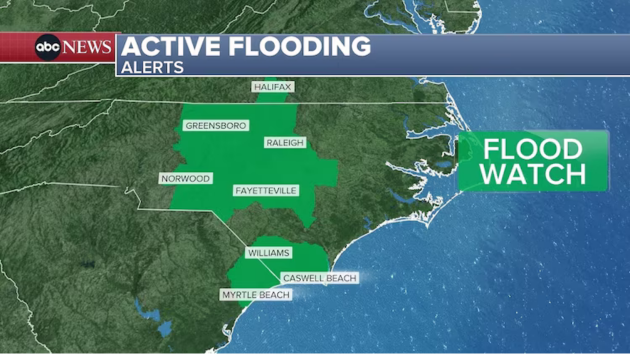
Flood watches remain in effect at least until Sunday night from Myrtle Beach to the west of Wilmington, North Carolina. Flood watches are expected to extend into parts of inland North Carolina, including Fayetteville and Raleigh, until Monday.
Chantal, the third named storm of the Atlantic hurricane season, was forecast to bring 2 to 4 inches of rain to portions of the eastern Carolinas, with isolated amounts up to 6 inches that could cause flash flooding.
Thunderstorms from the bands of Chantal may also produce isolated tornadoes, as well as lightning and gusty winds.
The storm was also expected to bring minor storm surges to parts of the Carolina coastline, with between 1 to 3 feet of storm surge possible during high tide for coastal areas under the tropical storm warnings.
Copyright © 2025, ABC Audio. All rights reserved.