From the National Weather Service in Birmingham:
Freeze Watch
URGENT – WEATHER MESSAGE
National Weather Service Birmingham AL
1218 PM CDT Mon Apr 7 2025
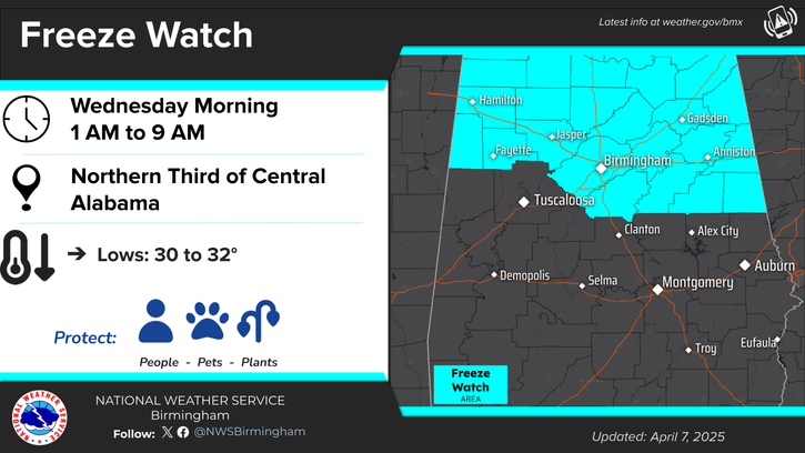
…FREEZE WATCH IN EFFECT FROM LATE TUESDAY NIGHT THROUGH WEDNESDAY MORNING…
* WHAT…Potential for sub-freezing temperatures ranging from 30 to 32 degrees.
* WHERE…Blount, Calhoun, Cherokee, Clay, Cleburne, Etowah, Fayette, Jefferson, Lamar, Marion, Randolph, Shelby, St. Clair, Talladega, Walker, and Winston Counties.
* WHEN…From late Tuesday night through Wednesday morning.
* IMPACTS…Frost and freeze conditions could kill crops and other sensitive vegetation.
PRECAUTIONARY/PREPAREDNESS ACTIONS…
Take steps now to protect tender plants from the cold.
From the National Weather Service in Huntsville:
Freeze Watch
URGENT – WEATHER MESSAGE
National Weather Service Huntsville AL
1043 AM CDT Mon Apr 7 2025
…FREEZE WATCH IN EFFECT FROM LATE TUESDAY NIGHT THROUGH WEDNESDAY MORNING…
* WHAT…Sub-freezing temperatures of 28-32 and development of widespread frost is possible.
* WHERE…All counties in northern Alabama.
* WHEN…From late Tuesday night through Wednesday morning.
* IMPACTS…Frost and freeze conditions could kill crops, other sensitive vegetation and possibly damage unprotected outdoor plumbing.
PRECAUTIONARY/PREPAREDNESS ACTIONS…
Take steps now to protect tender plants from the cold.