From the National Weather Service in Birmingham:
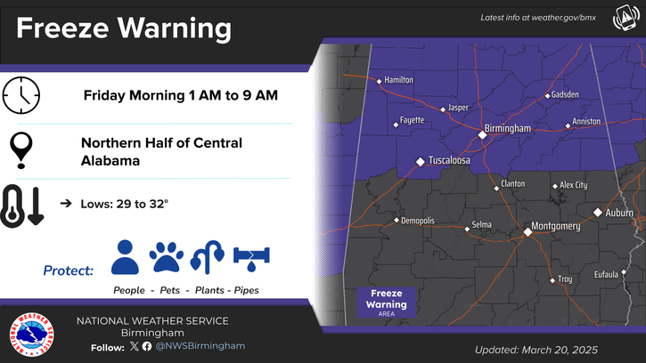
Freeze Warning
URGENT – WEATHER MESSAGE
National Weather Service Birmingham AL
1234 AM CDT Thu Mar 20 2025
…FREEZE WARNING REMAINS IN EFFECT FROM 1 AM TO 9 AM CDT FRIDAY…
* WHAT…Sub-freezing temperatures as low as 29 expected.
* WHERE…Blount, Calhoun, Cherokee, Clay, Cleburne, Etowah, Fayette, Jefferson, Lamar, Marion, Pickens, Randolph, Shelby, St. Clair, Talladega, Tuscaloosa, Walker, and Winston Counties.
* WHEN…From 1 AM to 9 AM CDT Friday.
* IMPACTS…Frost and freeze conditions could kill crops, other sensitive vegetation and possibly damage unprotected outdoor plumbing.
PRECAUTIONARY/PREPAREDNESS ACTIONS…
Take steps now to protect tender plants from the cold.
To prevent freezing and possible bursting of pipes they should be wrapped, drained, or allowed to drip slowly.
Those that have in ground sprinkler systems should drain them and cover above ground pipes to protect them from freezing.
From the National Weather Service in Huntsville:
Freeze Warning
URGENT – WEATHER MESSAGE
National Weather Service Huntsville AL
1248 AM CDT Thu Mar 20 2025
…FREEZE WARNING IN EFFECT FROM 1 AM TO 8 AM CDT FRIDAY…
* WHAT…Sub-freezing temperatures as low as 27-31 expected.
* WHERE…All counties in northern Alabama.
* WHEN…From 1 AM to 8 AM CDT Friday.
* IMPACTS…Frost and freeze conditions could kill crops, other sensitive vegetation and possibly damage unprotected outdoor plumbing.
PRECAUTIONARY/PREPAREDNESS ACTIONS…
Take steps now to protect tender plants from the cold.