Severe Thunderstorm Warning
Severe Thunderstorm Warning
ALC019-160315-
/O.NEW.KBMX.SV.W.0051.250316T0250Z-250316T0315Z/
BULLETIN – IMMEDIATE BROADCAST REQUESTED
Severe Thunderstorm Warning
National Weather Service Birmingham AL
950 PM CDT Sat Mar 15 2025
The National Weather Service in Birmingham has issued a
* Severe Thunderstorm Warning for…
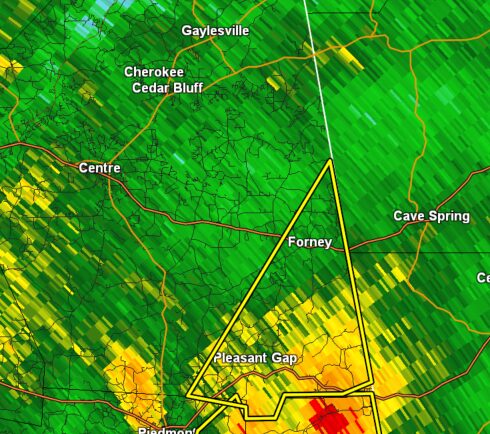
Southeastern Cherokee County in northeastern Alabama…
* Until 1015 PM CDT.
* At 950 PM CDT, a severe thunderstorm was located near Pleasant Gap, or 8 miles south of Forney, moving northeast at 75 mph.
HAZARD…70 mph wind gusts.
SOURCE…Radar indicated.
IMPACT…Expect considerable tree damage. Damage is likely to mobile homes, roofs, and outbuildings.
* Locations impacted include…
Forney, Spring Garden, and Pleasant Gap.
PRECAUTIONARY/PREPAREDNESS ACTIONS…
For your protection move to an interior room on the lowest floor of a building.
A Tornado Watch remains in effect until 300 AM CDT for northeastern and east central Alabama.
THUNDERSTORM DAMAGE THREAT…CONSIDERABLE
HAIL THREAT…RADAR INDICATED
MAX HAIL SIZE…<.75 IN
WIND THREAT…RADAR INDICATED
MAX WIND GUST…70 MPH
Stay with WEIS 100.5 FM, 990 AM, and the WEIS Radio app for the latest severe weather updates.