Tornado Warning
National Weather Service Huntsville AL
145 AM CST Sun Feb 16 2025
The National Weather Service in Huntsville Alabama has issued a
* Tornado Warning for…
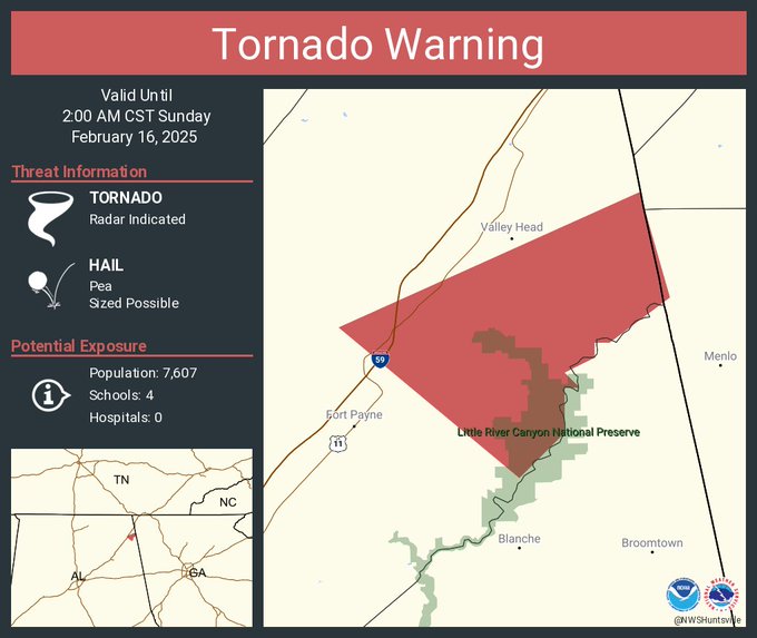
East central DeKalb County in northeastern Alabama…
* Until 200 AM CST.
* At 145 AM CST, a severe thunderstorm capable of producing a tornado was located near Fort Payne, moving northeast at 110 mph.
HAZARD…Tornado.
SOURCE…Radar indicated rotation.
IMPACT…Flying debris will be dangerous to those caught without shelter. Mobile homes will be damaged or destroyed. Damage to roofs, windows, and vehicles will occur. Tree damage is likely.
* This tornadic thunderstorm will remain over mainly rural areas of east central DeKalb County, including the following locations…
Desoto State Park, Valley Head, Mentone, Hammondville, and Little River Canyon NP.
PRECAUTIONARY/PREPAREDNESS ACTIONS…
TAKE COVER NOW! Move to a basement or an interior room on the lowest floor of a sturdy building. Avoid windows. If you are outdoors, in a mobile home, or in a vehicle, move to the closest substantial shelter and protect yourself from flying debris.
Tornadoes are extremely difficult to see and confirm at night. Do not wait to see or hear the tornado. TAKE COVER NOW!
TORNADO…RADAR INDICATED
MAX HAIL SIZE…<.75 IN
Tornado Warning
Severe Weather Statement
National Weather Service Huntsville AL
142 AM CST Sun Feb 16 2025
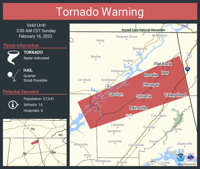
…A TORNADO WARNING REMAINS IN EFFECT UNTIL 200 AM CST FOR NORTHEASTERN DEKALB COUNTY…
At 141 AM CST, a severe thunderstorm capable of producing a tornado was located near Henagar, or 10 miles north of Fort Payne, moving northeast at 60 mph.
HAZARD…Tornado.
SOURCE…Radar indicated rotation.
IMPACT…Flying debris will be dangerous to those caught without shelter. Mobile homes will be damaged or destroyed. Damage to roofs, windows, and vehicles will occur. Tree damage is likely.
This dangerous storm will be near…
Henagar and Ider around 145 AM CST.
Other locations impacted by this tornadic thunderstorm include Sulpher Springs, Hammondville, Valley Head, and Mentone.
PRECAUTIONARY/PREPAREDNESS ACTIONS…
TAKE COVER NOW! Move to a basement or an interior room on the lowest floor of a sturdy building. Avoid windows. If you are outdoors, in a mobile home, or in a vehicle, move to the closest substantial shelter
and protect yourself from flying debris.
Tornadoes are extremely difficult to see and confirm at night. Do not wait to see or hear the tornado. TAKE COVER NOW!
TORNADO…RADAR INDICATED
MAX HAIL SIZE…0.00 IN
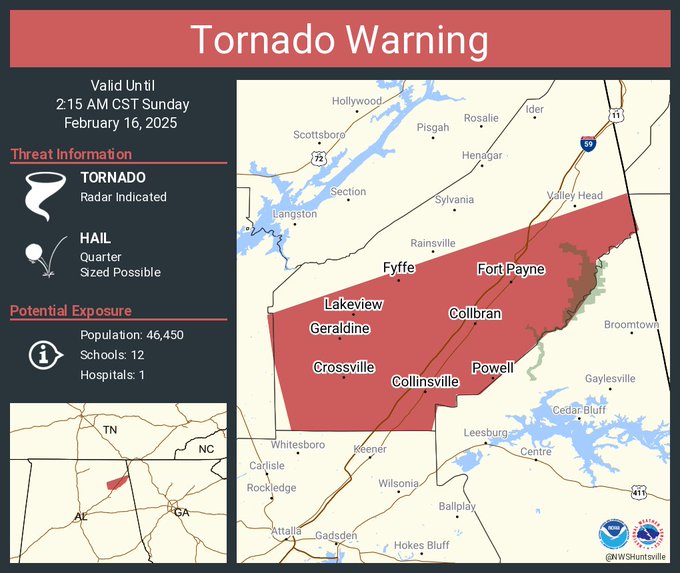
Tornado Warning
Severe Weather Statement
National Weather Service Huntsville AL
135 AM CST Sun Feb 16 2025
…A TORNADO WARNING REMAINS IN EFFECT UNTIL 215 AM CST FOR SOUTHEASTERN DEKALB COUNTY…
At 135 AM CST, a severe thunderstorm capable of producing a tornado was located near Fort Payne, moving northeast at 75 mph.
HAZARD…Tornado and quarter size hail.
SOURCE…Radar indicated rotation.
IMPACT…Flying debris will be dangerous to those caught without shelter. Mobile homes will be damaged or destroyed. Damage to roofs, windows, and vehicles will occur. Tree damage is likely.
Locations impacted include…
Fort Payne, Rainsville, Valley Head, Hammondville, Mentone, Pine Ridge, Dog Town, Collbran, Guest, and Little River Canyon NP.
PRECAUTIONARY/PREPAREDNESS ACTIONS…
Tornadoes are extremely difficult to see and confirm at night. Do not wait to see or hear the tornado. TAKE COVER NOW!
TORNADO…RADAR INDICATED
MAX HAIL SIZE…1.00 IN
Stay with WEIS 100.5 FM, 990 AM, and the WEIS Radio app for all the latest weather updates.