From the National Weather Service in Birmingham:
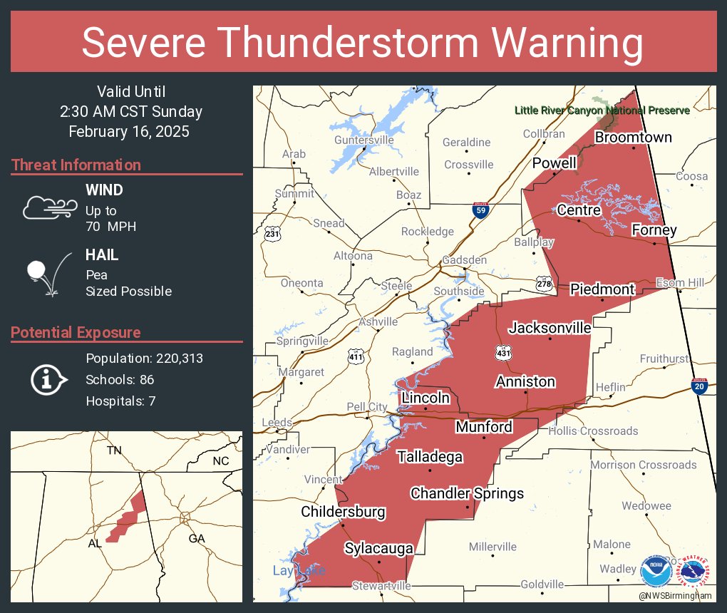
Severe Thunderstorm Warning
National Weather Service Birmingham AL
123 AM CST Sun Feb 16 2025
The National Weather Service in Birmingham has issued a
* Severe Thunderstorm Warning for…
Talladega County in east central Alabama…
Calhoun County in east central Alabama…
Cherokee County in northeastern Alabama…
* Until 230 AM CST.
* At 123 AM CST, severe thunderstorms were located along a line extending from Fyffe to near Odenville to Wilton, moving east at 65 mph.
HAZARD…70 mph wind gusts.
SOURCE…Radar indicated.
IMPACT…Expect considerable tree damage. Damage is likely to mobile homes, roofs, and outbuildings.
* Locations impacted include…
Anniston, Oxford, Talladega, Sylacauga, Jacksonville, Childersburg, Piedmont, Centre, Wilsonville, Cedar Bluff, Talladega Springs, Cobb Town, Fort McClellan, Saks, Little River Canyon National Preserve, Forney, West End-Cobb Town, Centre Municipal Airport, Lincoln, and Glencoe.
PRECAUTIONARY/PREPAREDNESS ACTIONS…
For your protection move to an interior room on the lowest floor of a building.
A Tornado Watch remains in effect until 600 AM CST for central, northeastern and east central Alabama.
THUNDERSTORM DAMAGE THREAT…CONSIDERABLE
HAIL THREAT…RADAR INDICATED
MAX HAIL SIZE…<.75 IN
WIND THREAT…RADAR INDICATED
MAX WIND GUST…70 MPH
From the National Weather Service in Huntsville:
Severe Thunderstorm Warning
Severe Weather Statement
National Weather Service Huntsville AL
130 AM CST Sun Feb 16 2025
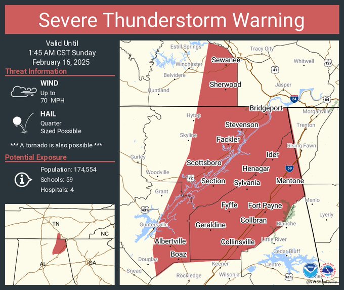
…A SEVERE THUNDERSTORM WARNING REMAINS IN EFFECT UNTIL 145 AM CST FOR EASTERN JACKSON AND DEKALB COUNTIES…
At 130 AM CST, severe thunderstorms were located along a line extending from 8 miles northwest of Pikeville to near Lookout Mountain to near Fort Payne to near Neely Henry Lake, moving east at 75 mph.
HAZARD…60 mph wind gusts and penny size hail.
SOURCE…Radar indicated.
IMPACT…Expect damage to roofs, siding, and trees.
Locations impacted include…
Scottsboro, Fort Payne, Rainsville, Bridgeport, Henagar, Stevenson, Crossville, Sylvania, Fyffe, and Hollywood.
PRECAUTIONARY/PREPAREDNESS ACTIONS…
A Tornado Watch remains in effect until 600 AM CST for northeastern Alabama…and Middle Tennessee.
Remain alert for a possible tornado! Tornadoes can develop quickly from severe thunderstorms. If you spot a tornado go at once into the basement or small central room in a sturdy structure.
TORNADO…POSSIBLE
HAIL THREAT…RADAR INDICATED
MAX HAIL SIZE…0.75 IN
WIND THREAT…RADAR INDICATED
MAX WIND GUST…60 MPH
Stay with WEIS 100.5 FM, 990 AM, and the WEIS Radio app for all the latest weather updates.