Hurricane Helene Local Statement Advisory/Issued by National Weather Service Birmingham AL
**HELENE EXPECTED TO BRING FLOODING RAINS AND WINDY CONDITIONS TO EAST ALABAMA**
NEW INFORMATION
* CHANGES TO WATCHES AND WARNINGS:
– None
* CURRENT WATCHES AND WARNINGS:
– A Tropical Storm Warning is in effect for Barbour, Bullock, Chambers, Cherokee, Cleburne, Lee, Macon, Pike, Randolph, and Russell.
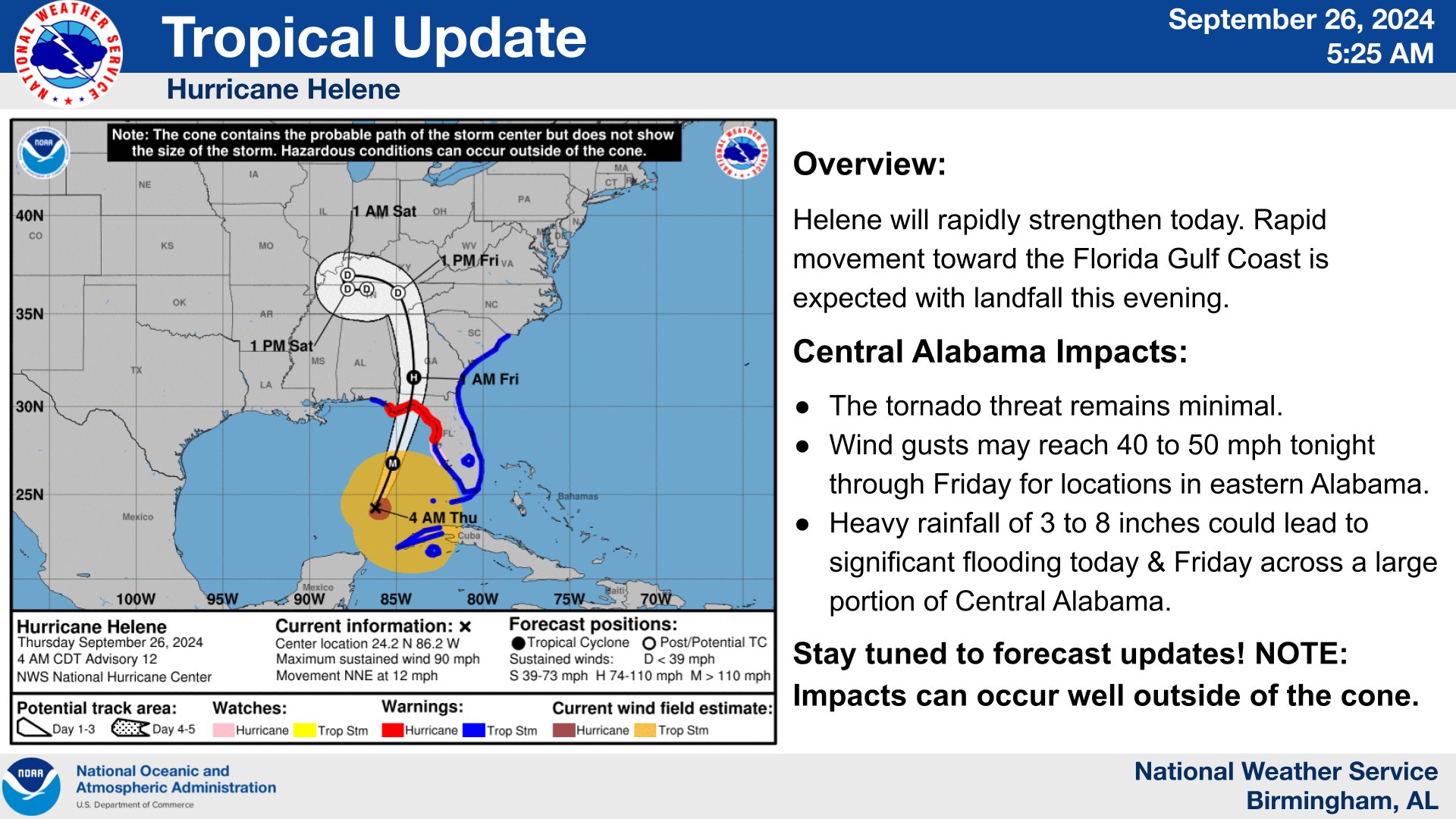
* STORM INFORMATION:
– About 720 miles south of Birmingham AL or about 640 miles south of Montgomery AL
– 23.1N 86.6W
– Storm Intensity 85 mph
– Movement North or 360 degrees at 9 mph
SITUATION OVERVIEW
——————
Hurricane Helene is currently moving toward the north at 10 mph through the southern Gulf of Mexico. A turn toward the north northeast with an increase in forward speed is expected tonight through Thursday, bringing the center of Helene across the eastern Gulf of Mexico and to the Florida Big Bend coast by Thursday evening. After landfall, Helene is expected to slow down and turn toward the northwest over the southeastern United States Friday and Saturday.
An area of 40 to 50 mph wind gusts is expected to occur across East Alabama Thursday evening through Friday morning, with the highest gusts near the Georgia state line. With these wind speeds, expect downed trees and power outages across eastern portions of Central Alabama. Additionally, rainfall amounts of 4 to 7 inches are expected, across much of eastern portions of Central Alabama, with locally higher amounts to 10 inches. This will result in minor to moderate river flooding as well as flash flooding, some of which may be locally significant.
POTENTIAL IMPACTS
—————–
* FLOODING RAIN:
Protect against life-threatening rainfall flooding having possible extensive impacts across eastern portion of Central Alabama. Potential impacts include:
– Major rainfall flooding may prompt many evacuations and rescues.
– Rivers and tributaries may rapidly overflow their banks in multiple places. Small streams, creeks, and ditches may become dangerous rivers. Flood control systems and barriers may become stressed.
– Flood waters can enter many structures within multiple communities, some structures becoming uninhabitable or washed away. Streets and parking lots become rivers of moving water with underpasses submerged. Driving conditions become dangerous. Many road and bridge closures with some weakened or washed out.
Protect against dangerous rainfall flooding having possible limited to significant impacts across the Interstate 65 corridor.
* WIND:
Protect against dangerous wind having possible significant impacts across eastern portions of Central Alabama. Potential impacts in this area include:
– Some damage to roofing and siding materials, along with damage to porches, awnings, carports, and sheds. A few buildings experiencing window, door, and garage door failures. Mobile and manufactured homes damaged, especially if unanchored. Unsecured lightweight objects become dangerous projectiles.
– Several large trees snapped or uprooted. Several fences and roadway signs blown over.
– Some roads impassable from large debris, and more within urban or heavily wooded places.
– Scattered power and communications outages, but more prevalent in areas with above ground lines.
Also, protect against hazardous wind having possible limited impacts across the Interstate 65 corridor.
PRECAUTIONARY/PREPAREDNESS ACTIONS
———————————-
* EVACUATIONS:
Follow the advice of local officials.
* OTHER PREPAREDNESS INFORMATION:
Now is the time to complete all preparations to protect life and property in accordance with your emergency plan. Ensure you are in a safe location before the onset of strong winds or possible flooding.
Rapidly rising flood waters are deadly. If you are in a flood-prone area, consider moving to higher ground. Never drive through a flooded roadway. Remember, turn around don`t drown!
If in a place that is vulnerable to high wind, such as near large trees or in a mobile or manufactured home, consider moving to a safer shelter before the onset of strong winds or flooding.
Closely monitor weather.gov, NOAA Weather radio or local news outlets for official storm information. Be ready to adapt to possible changes to the forecast. Ensure you have multiple ways to receive weather warnings.