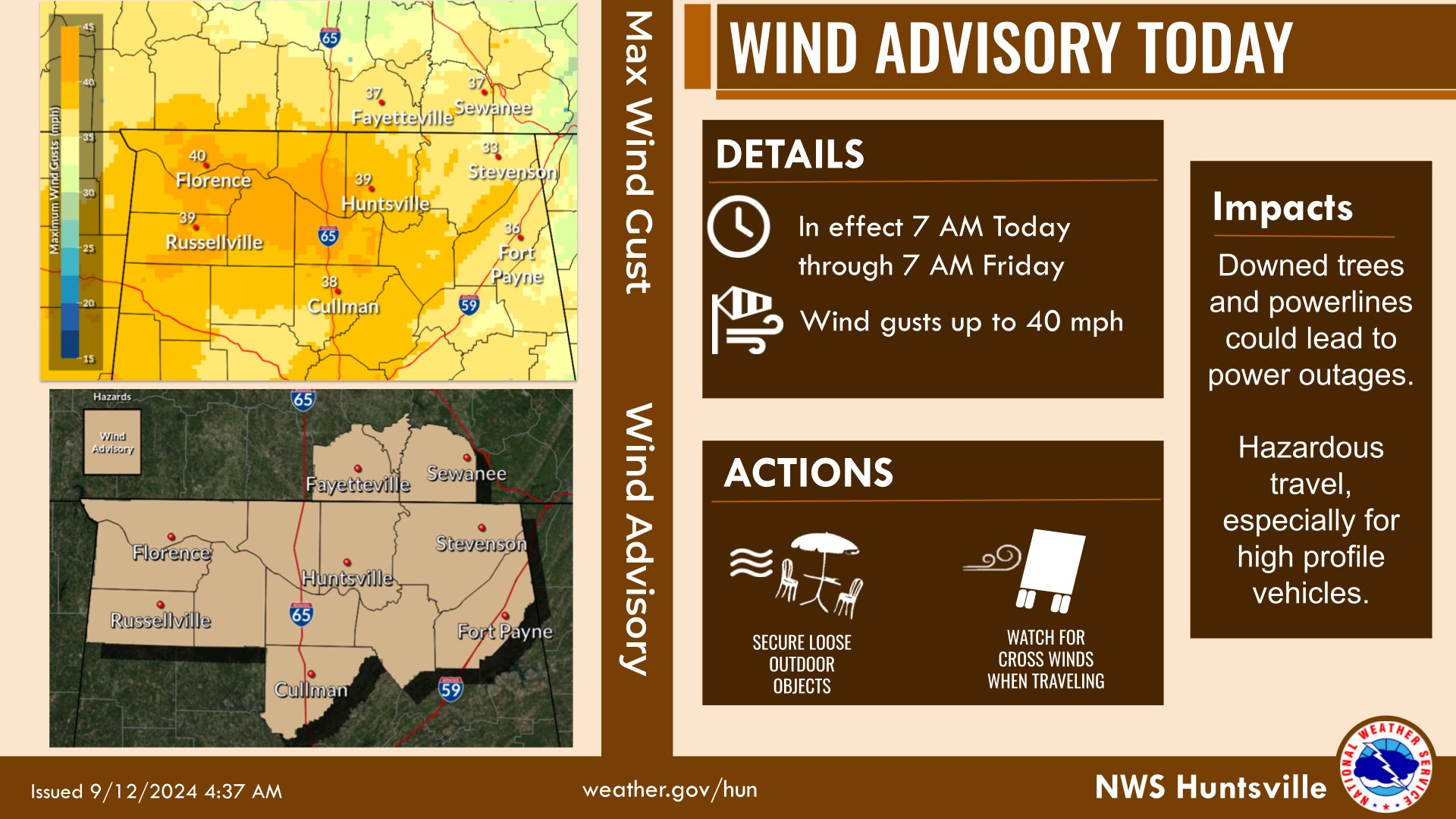
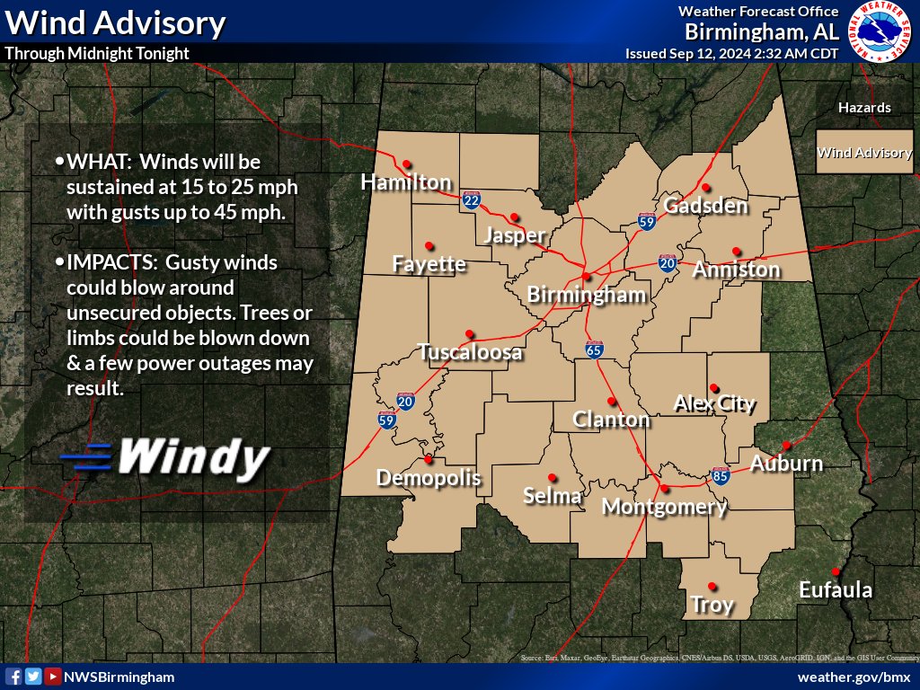
Wind Advisory/URGENT – WEATHER MESSAGE / National Weather Service Birmingham AL
Marion-Lamar-Fayette-Winston-Walker-Blount-Etowah-Calhoun-Cherokee-Cleburne-Pickens-Tuscaloosa-Jefferson-Shelby-St. Clair-Talladega-Clay-Sumter-Greene-Hale-Perry-Bibb-Chilton-Coosa-Tallapoosa-Marengo-Dallas-Autauga-Lowndes-Elmore-Montgomery-Macon-Bullock-Pike Including the cities of Hamilton, Hoover, Fayette, Sulligent, Tallassee, Gadsden, Vernon, Ashland, Demopolis, Prattville, Columbiana, Linden, Pell City, Alabaster, Montgomery, Hayneville, Sylacauga, Moundville, Rockford, Carrollton, Livingston, Heflin, Greensboro, Talladega, Pelham, Centreville, Dadeville, Wetumpka, Alexander City, Double Springs, Moody, Oneonta, Troy, Birmingham, Marion, Clanton, Tuscaloosa, Centre, Eutaw, Selma, Jasper, Anniston, Union Springs, Fort Deposit, and Tuskegee
WIND ADVISORY REMAINS IN EFFECT UNTIL MIDNIGHT CDT TONIGHT
* WHAT
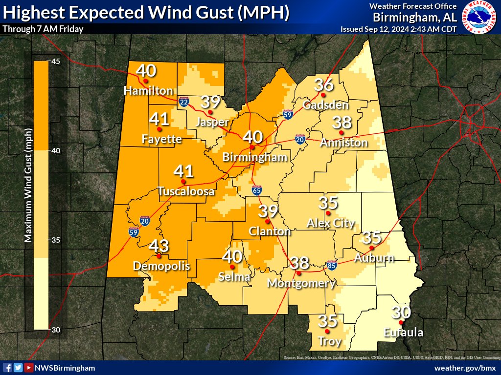
Southeast winds 15 to 25 mph with gusts up to 45 mph.
* WHERE
Autauga, Bibb, Blount, Bullock, Calhoun, Cherokee, Chilton, Clay, Cleburne, Coosa, Dallas, Elmore, Etowah, Fayette, Greene, Hale, Jefferson, Lamar, Lowndes, Macon, Marengo, Marion, Montgomery, Perry, Pickens, Pike, Shelby, St. Clair, Sumter, Talladega, Tallapoosa, Tuscaloosa, Walker, and Winston Counties.
* WHEN
Until midnight CDT tonight.
* IMPACTS
Gusty winds will blow around unsecured objects. Trees could be blown down and a few power outages may result.
PRECAUTIONARY/PREPAREDNESS ACTIONS
Winds this strong can make driving difficult, especially for high profile vehicles. Use extra caution. Secure outdoor objects.
A WIND ADVISORY has also been issued by the National Weather Service of Huntsville for North Alabama, including DeKalb and Marshall Counties, through 7am Friday, Sept. 13.