
Special Weather Statement
National Weather Service Birmingham AL
1126 AM CDT Fri Jul 5 2024
ALZ020-051715-
Cherokee AL-
1126 AM CDT Fri Jul 5 2024
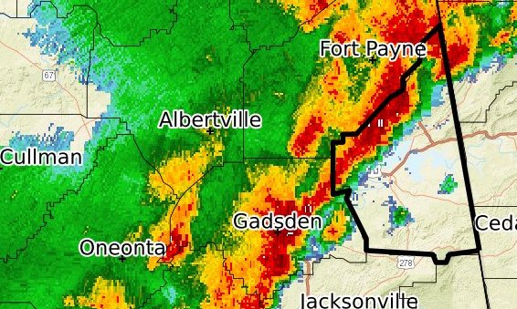
...STRONG THUNDERSTORMS WILL IMPACT CHEROKEE COUNTY THROUGH 1215 PM
CDT...
At 1125 AM CDT, Doppler radar was tracking strong thunderstorms along
a line extending from 7 miles north of Little River Falls to
Slackland. Movement was east at 15 mph.
HAZARD...Wind gusts up to 40 mph.
SOURCE...Radar indicated.
IMPACT...Gusty winds could knock down tree limbs and blow around
unsecured objects.
Locations impacted include...
Centre, Cedar Bluff, Little River Canyon National Preserve, Forney,
Centre Municipal Airport, Leesburg, Sand Rock, Gaylesville, Tennala,
Cherokee Rock Village, Pleasant Gap, Cornwall Furnace Park, Blanche,
Eastern Weiss Lake, Little River Falls, Slackland, Western Weiss
Lake, Moshat, Ball Flat, and Coloma.
PRECAUTIONARY/PREPAREDNESS ACTIONS...
If outdoors, consider seeking shelter inside a building.
Torrential rainfall is also occurring with these storms and may lead
to localized flooding. Do not drive your vehicle through flooded
roadways.
Frequent cloud to ground lightning is occurring with these storms.
Lightning can strike 10 miles away from a thunderstorm. Seek a safe
shelter inside a building or vehicle.
&&
LAT...LON 3397 8540 3396 8549 3394 8550 3394 8553
3396 8554 3397 8574 3400 8574 3410 8580
3412 8579 3411 8584 3424 8584 3424 8581
3426 8581 3426 8577 3435 8567 3437 8563
3440 8563 3444 8558 3449 8557 3453 8552
TIME...MOT...LOC 1625Z 272DEG 13KT 3450 8558 3412 8581
MAX HAIL SIZE...0.00 IN
MAX WIND GUST...40 MPH

You must be logged in to post a comment.