
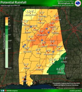
Waves of heavy rain and thunderstorms will continue to move across the area through Saturday. One wave will occur this afternoon and may bring a risk of a few strong to severe thunderstorms. Rain will be mostly focused in the south on Friday, but another widespread round of showers and storms will occur on Saturday. Some of those storms could also become strong to severe, especially for areas near and east of I-65. An additional 2 to 3 inches of rainfall, with locally higher amounts, is forecast through Saturday. Therefore, the flooding risk continues as rain falls on saturated soils.
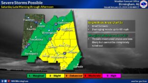
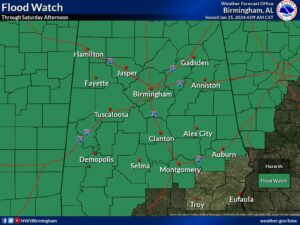
Updated Forecast Calls for a Marginal Risk of severe storms for today and a Slight risk for Saturday. The Flood Watch has been extended through Saturday.
There is a Threat of Strong to Severe Weather Today across all of Central Alabama and again on Saturday. The timing of the severe weather for the northeast Alabama area is now through 6pm and Saturday from late morning through the afternoon bringing the threat of a brief tornado possible and winds up to 60 miles per hour.
Flooding can occur in all areas north of I-85 Now through Saturday afternoon with waves of heavy rain and thunderstorms moving across the region bringing an additional 2 to 3 inches of accumulation which will support the risk of flooding.


You must be logged in to post a comment.