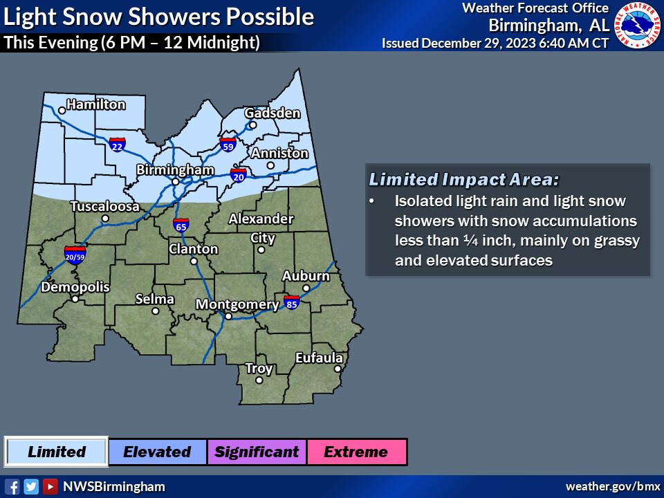
A weather system is expected to move through the Ohio River Valley with wrap-around moisture stretching down into the northern half of Alabama this Friday evening. Temperatures will be in the middle to upper 30s across this area to start this morning, with very minimal frozen precipitation and no accumulations expected today. Temperatures warm into the 40s for these areas during the day today with mainly light rain showers or sprinkles expected. Temperatures drop into the lower to middle 30s when the second (better wave) of moisture/precipitation moves in as a rain/snow mix late today toward sunset from the west. Isolated accumulations of snow are possible for portions for the northern third of Central Alabama (area shaded in light blue on graphic, see below), but amounts should be limited to less than 1/4 inch mainly on grassy and/or elevated surfaces. A few flurries may be noted before the precipitation ends a row of counties south of there, but no accumulation is expected south of the shaded area. Any precipitation after midnight should be minimal with no additional accumulations in the shaded area.
Changes from previous forecast: Light blue shaded area of possible accumulations is a little further south to now include the northern third of Central Alabama.
Highlights:
What: Snow accumulations of less than 1/4 inch on grassy or elevated surfaces.
Where: Portions of the northern third of Central Alabama.
When: This Friday evening from 6 PM to 12 Midnight
Impacts: Light accumulations on grassy and elevated surfaces.
For Complete Up To Date Weather Information, Stay Tuned To WEIS Radio, 100.5 FM, 990 AM, online at weisradio.com and on the WEIS Radio App!!


