Hazardous Weather Outlook / National Weather Service Birmingham AL
This Hazardous Weather Outlook is for the counties served by the National Weather Service office in Birmingham.
Outlook through Tonight.
Non thunderstorm wind gusts up to 50 mph are possible after midnight tonight. Downed trees and power outages may occur.
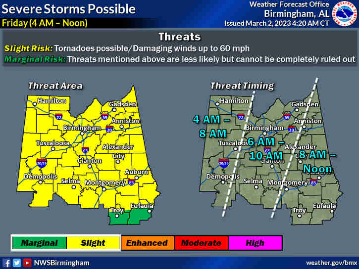
Severe thunderstorms are possible across far western Central Alabama after 4am. Threats include tornadoes and damaging winds up to 60 mph.
Friday through Wednesday.
Severe thunderstorms are possible across all of Central Alabama through noon on Friday. Threats include tornadoes and damaging winds up to 60 mph.
Non thunderstorm wind gusts up to 50 mph are possible through Friday evening. Downed trees and power outages may occur.
SPOTTER INFORMATION STATEMENT
Activation of storm spotters and Emergency Management may be needed through Friday.
Wind Advisory
URGENT – WEATHER MESSAGE
National Weather Service Birmingham AL
WIND ADVISORY IN EFFECT FROM MIDNIGHT TONIGHT TO 9 PM CST FRIDAY
* WHAT
South winds 15 to 25 mph with gusts up to 50 mph expected.
* WHERE
Central Alabama.
* WHEN
From midnight tonight to 9 PM CST Friday.
* IMPACTS
Gusty winds could blow around unsecured objects. Tree limbs could be blown down and a few power outages may result.
PRECAUTIONARY/PREPAREDNESS ACTIONS…
Use extra caution when driving, especially if operating a high profile vehicle. Secure outdoor objects.