
Confidence has increased some about the potential for severe weather for south Alabama on Tuesday night into Wednesday morning.
The National Weather Service in warned of the potential for “significant” severe weather for southwest Alabama and said all forms of severe weather will be possible for south Alabama starting Tuesday night.
Tornadoes, wind gusts up to 70 mph and heavy rain will all be possible across that part of the state ahead of a cold front.
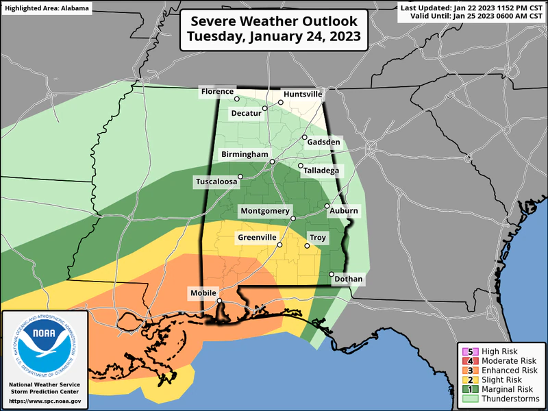
NOAA’s Storm Prediction Center has added a Level 3 out of 5 risk for severe weather for southwest Alabama — including the Mobile area — for the Tuesday night-Wednesday morning timeframe.
A Level 3 risk, or enhanced risk, means numerous severe storms will be possible.
Areas to the north and east of that region, including Troy and Greenville, will also have a Level 2 risk for severe weather. Scattered severe storms will be possible there.
A Level 1 risk extends farther north and east and includes places such as Montgomery, Tuscaloosa, Birmingham, Auburn and Dothan. A Level 1 risk means isolated severe storms will be possible.
The weather service also warned that it could be windy before the storms arrive — and gusts of 50-60 mph aren’t out of the question, especially in south Alabama.
Those winds, coupled with recent rains, could lead to trees coming down and power outages on Tuesday — before the storms arrive.
The storms are expected to arrive overnight, and it’s important to make sure you have multiple ways to get warnings — even if you are asleep. Don’t rely on an outdoor siren to wake you up, because they were not designed to be heard indoors.
Make sure devices are charged up and not silenced on Tuesday night — or have battery-powered weather radios activated.
For coastal Alabama, the expected high winds will also lead to a high risk of rip currents and could cause coastal flooding Tuesday night into Wednesday morning. Minor flooding will also be possible around Mobile Bay.
The National Weather Service in Mobile said a few showers will be possible across southwest Alabama starting on Tuesday afternoon, but the stronger storms won’t arrive in the region until late Tuesday night or early Wednesday morning.
Forecasters will be watching two things: A warm front that is expected to lift northward through the region from the Gulf, and a fast-moving cold front approaching Alabama from the west.
The weather service is expecting a line of rain and storms to advance from west to east across the state. The storms are not expected to be severe in north and north-central Alabama, but they could be very strong in areas south of the warm front.
The weather service said a lot of the ingredients will be in place for severe weather, but there is still a question about whether there will be enough instability to support a widespread severe weather event. Forecast scenarios range from a significant round of severe weather — to hardly any at all.
Forecasters will get a clearer picture on expected instability on Tuesday.
The storms are expected to move out of Alabama during the day on Wednesday, and cooler and drier weather is expected into the weekend.


You must be logged in to post a comment.