
The third day of 2023 promises to be a stormy one for Alabama.
Severe weather is in the forecast for the entire state, and tornadoes — including a few strong ones — damaging winds, hail and flooding rain will all be possible all day today, according to forecasters.
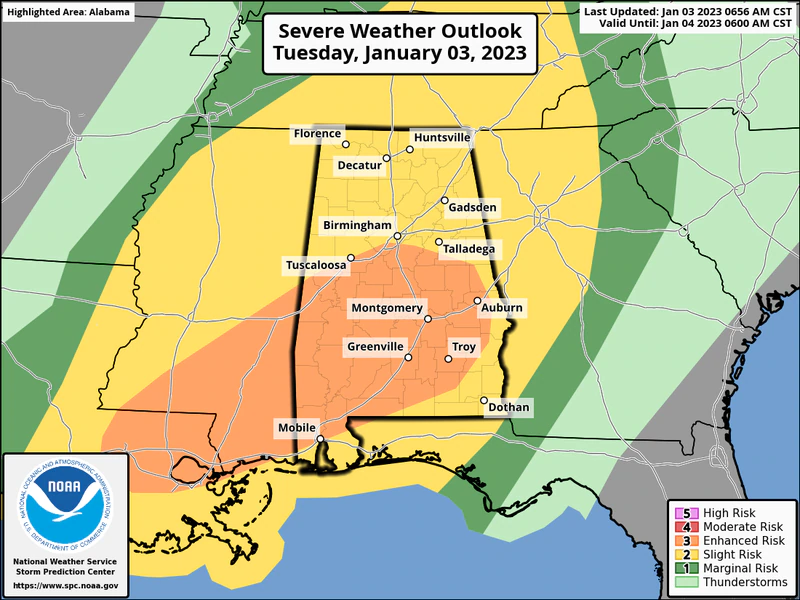
NOAA’s Storm Prediction Center is maintaining a Level 3 out of 5, or enhanced, risk for severe weather for parts of south and south-central Alabama today.
A Level 3 risk means that “numerous” severe storms will be possible.
The rest of Alabama has a Level 2 (slight) risk, which means that scattered severe storms will be possible.
Storms were firing to the west of Alabama early Tuesday morning. A tornado watch is in effect for parts of Mississippi and Tennessee and stretches all the way to Alabama’s western border.
The SPC continued to watch the evolution of storms to the west and said just before 8 a.m. that a new tornado watch will likely be needed for parts of Alabama later this morning:
The National Weather Service said that today’s storms could come in several waves. They will be possible from this morning through the overnight hours.
The first wave is expected to approach western Alabama later this morning. It could come in the form of clusters of storms and could bring damaging winds, hail and even a few tornadoes, according to the weather service.
Those storms are expected to move across the state through the morning and into the afternoon hours.
A cold front will still be lagging well to the west and could bring another wave of storms to Alabama later today.
The weather service said a second wave of storms will be possible later this evening as the front moves into Alabama from the west. Those storms could persist until early Wednesday morning.
Once the cold front moves through, the threat for severe weather will be over, the weather service said.
Today’s rain could add up. The weather service has issued a flood watch for parts of central and south Alabama.

The Alabama counties in green will be under flood watches starting at noon. Note the flash flood warnings in red to the west of Alabama as storms move through early Tuesday morning.
Forecasters said 1 to 4 inches of rain will be possible with repeated rounds of storms — with some areas possibly getting up to 6 inches.
Parts of south-central Alabama could get up to 6 inches of rain through noon Wednesday, and flood watches will be in effect starting at noon.
There are three flood watches, one for central Alabama, one for southwest Alabama and one for southeast Alabama.
The counties in the central Alabama flood watch are Autauga, Barbour, Bullock, Chambers, Chilton, Coosa, Dallas, Elmore, Lee, Lowndes, Macon, Marengo, Montgomery, Perry, Pike, Russell and Tallapoosa. That watch will be in effect from noon today until Wednesday morning.
The counties in the southwest Alabama watch are inland Baldwin and Mobile as well as Butler, Choctaw, Clarke, Conecuh, Covington, Crenshaw, Escambia, Monroe, Washington and Wilcox. It will be in effect from noon today through late tonight.
The flood watch for southeast Alabama includes Coffee, Dale and Henry counties and will be in effect from noon today until Wednesday afternoon.
Cooler and drier weather is expected across Alabama following the front. The next chance for rain will come over the weekend, but so far no severe weather is expected.
(NWS/AL.COM)


You must be logged in to post a comment.