Hazardous Weather Outlook
National Weather Service Birmingham AL / 443 AM CDT Wed Jun 8 2022
Marion-Lamar-Fayette-Winston-Walker-Blount-Etowah-Calhoun-Cherokee-Cleburne-Pickens-Tuscaloosa-Jefferson-Shelby-St.Clair-Talladega-Clay-Randolph-Sumter-Greene-Hale-Perry-Bibb-Chilton-Coosa-Tallapoosa-Chambers-Marengo-Dallas-Autauga-Lowndes-Elmore-Montgomery-Macon-Bullock-Lee-Russell-Pike-Barbour-
This Hazardous Weather Outlook is for the counties served by the National Weather Service office in Birmingham.
Outlook through Tonight.
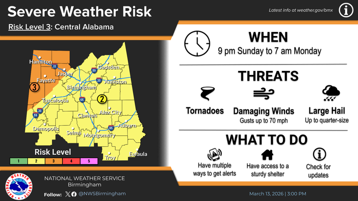
Strong to severe storms may occur today into this evening across Central Alabama. Multiple waves of convection are expected with breaks in between. Damaging winds and large hail will be the main threats. Heavy rainfall may also lead to localized flooding in urban and poor drainage areas.
Thursday through Tuesday.
Another system is expected to move into the area Friday afternoon through Friday night. This could lead to severe storms capable of producing damaging winds and large hail, mainly across the southwest half of Central Alabama.
SPOTTER INFORMATION STATEMENT
Activation of storm spotters and emergency management may be needed today into this evening and again on Friday.